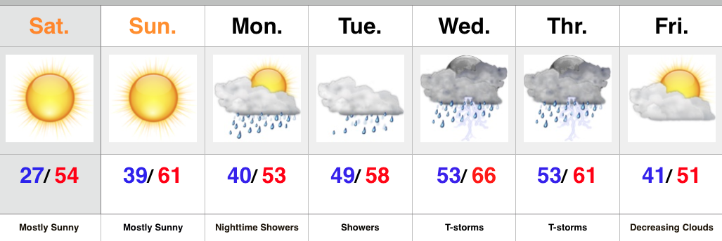
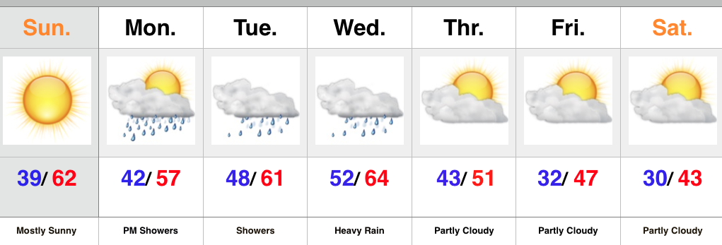
November 2015 archive

Nice Today Before Our Next Storm Arrives…

Screen Shot 2015-11-15 at 8.55.18 AMHighlights:

  • Beautiful Sunday
  • Clouds and rain return
  • Colder late week
  • Eyeing a potentially wintry end to November

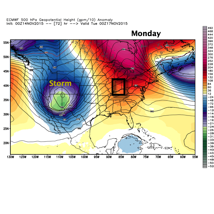
Our next storm system is coming ashore along the West Coast this morning.  That storm will impact our weather this week, but today we’ll focus on the sunshine and beautiful conditions.  Temperatures will climb into the lower to middle 60s.  With what lies ahead, we’d highly suggest taking advantage of the nice weather today and finish up any of that outdoor work you may have.

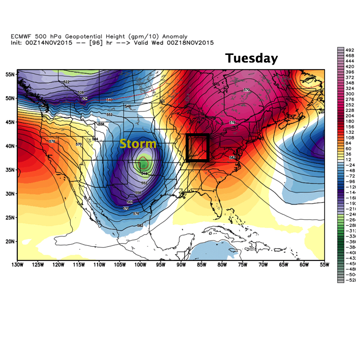
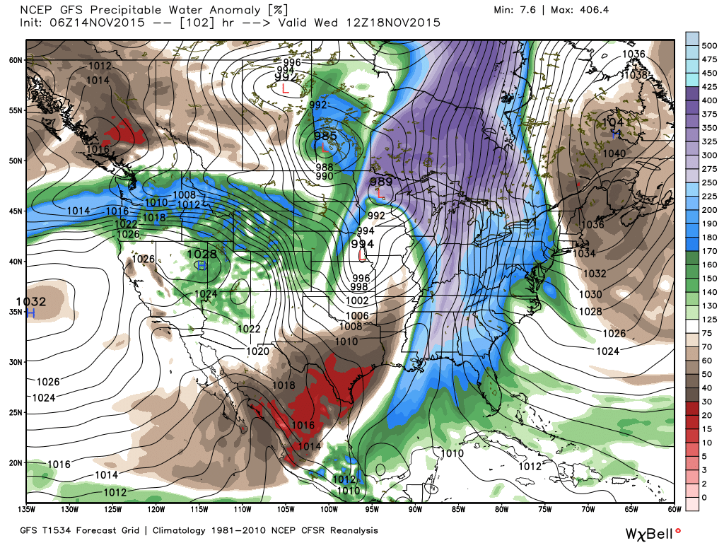
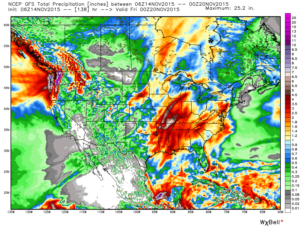
Clouds will increase Monday and the initial surge of moisture will provide showers and light rain by afternoon and evening.  A strong southerly flow continues Tuesday into Wednesday with periods of rain.  It won’t rain the entire time, but more times than not.  A push of heavy rain still appears likely Tuesday night into Wednesday.

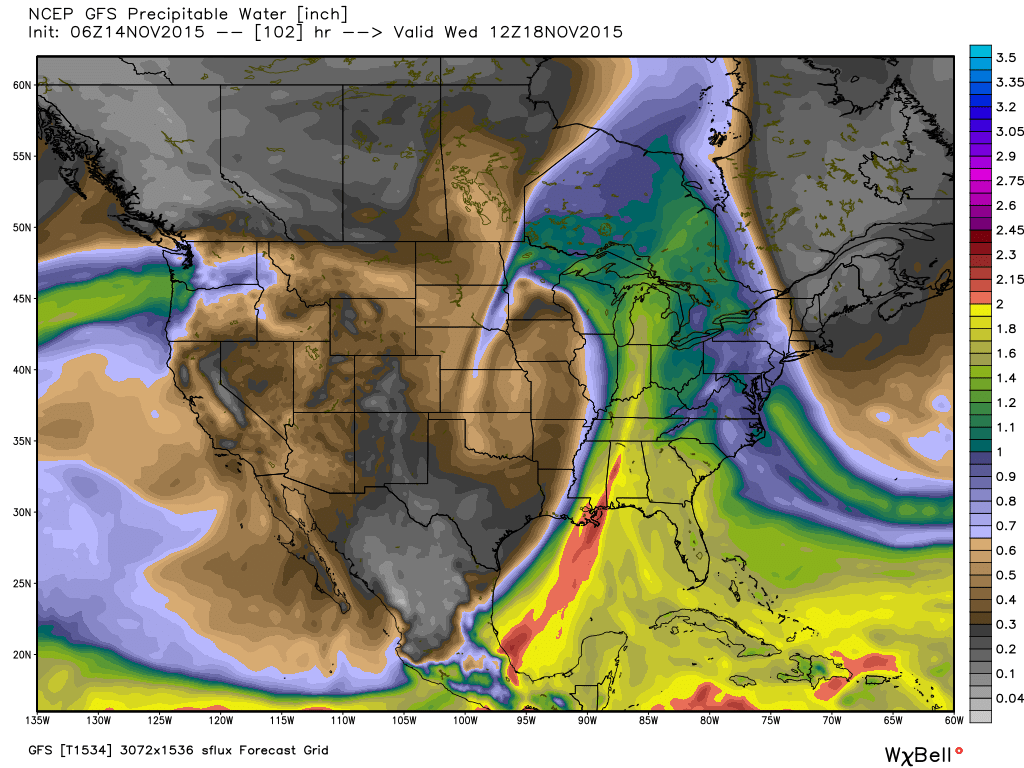
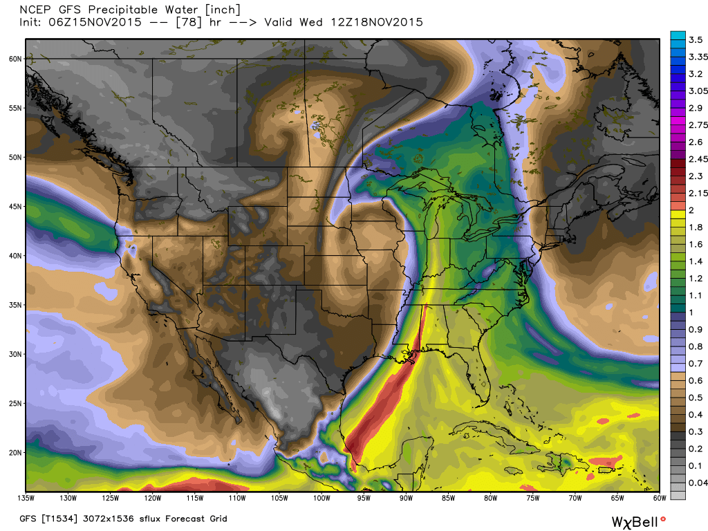
The image below is a look at forecast PWATs, thanks to Weatherbell.com, for Tuesday night.  When these values reach 1.5″-2″ that’s a good indication for very heavy rains.  We’ll continue to forecast widespread 2″+ type rainfall with this storm system.

gfs_pwat_conus2_14
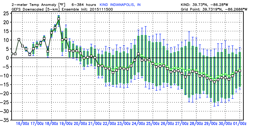
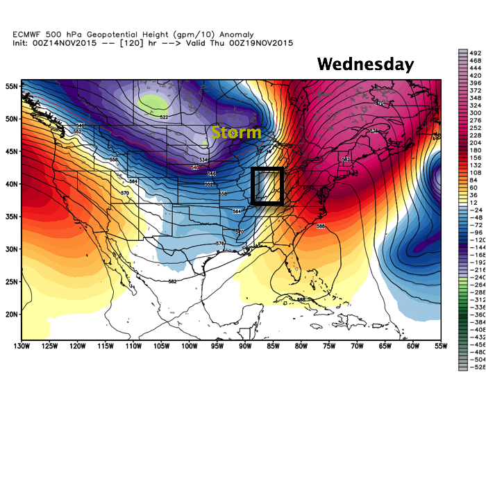
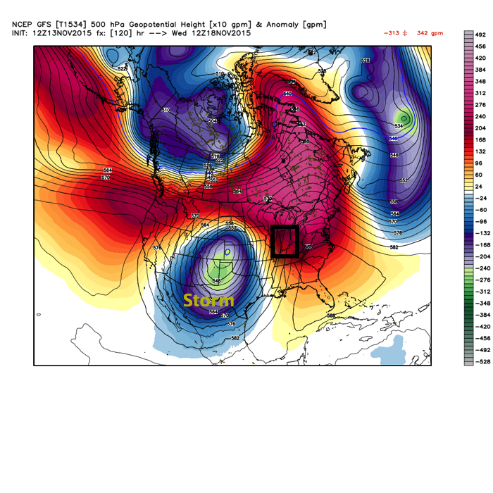
Once this next storm moves out, we’ll get back to drier and colder times to end the work week.  Attention will then shift to a colder, potentially wintry, end to the month, including the Thanksgiving holiday. It’s too early for specifics on storminess, but model data does hint at a storm of “interest” around Thanksgiving.  With colder air making a return, it’s certainly possible this next storm has a wintry component to it…

The latest GFS ensemble temperature anomaly chart shows the colder than average pattern setting in to wrap up November.

KIND_2015111500_nxa_384

Permanent link to this article: https://indywx.com/nice-today-before-our-next-storm-arrives/

Big, Wet Storm System Sitting On Deck…

Enjoy the weekend, my friends, as a big and wet storm system awaits on deck to impact early to mid week across the region.

November, so far, has followed suit of the past few months in a much drier than normal regime.  Over the past (7) days heaviest rains fell across SE portions of the state.  On the month so far, IND sits around 1″ below normal.

Past 7 day precipitation anomalies, courtesy of the MidWest Climate Watch.

Past 7 day precipitation anomalies, courtesy of the MidWest Climate Watch.

That rainfall deficit may be eaten up over the course of a couple days as our next storm system rolls off the Rockies and into the Plains.  (Track sound familiar)?

Monday

Tuesday

WednesdayThe storm will tap into the Gulf of Mexico and include a deep southerly flow plenty capable of producing a heavy rain event across the region.  Note PWATs (precipitable water) nearly 300% of normal.PWAT

gfs_pwat_anom_conus2_18

We target Tuesday night-Wednesday as the focal point for heaviest rain potential and model data remains firm on general consensus of 2″-3″ falling with this next storm system, including locally heavier totals.

soflow

raintotalsAfter this next storm, attention will begin to shift towards a colder pattern setting up for late November, including Thanksgiving…

Permanent link to this article: https://indywx.com/big-wet-storm-system-sitting-on-deck/

Cold Night Coming; Next Big Storm Slated For Next Week…

Screen Shot 2015-11-13 at 4.04.40 PMHighlights:

  • Moderating temperatures after a hard freeze
  • Next big storm arrives early next week
  • Wintry fun and games around Thanksgiving

Today has featured wall-to-wall sunshine and while it’s looked great from the inside looking out, that wind is still whipping!  Gusts have reached 40 MPH in spots across central and northern parts of the state.

Winds will finally die down tonight and with clear skies in place a hard freeze awaits for central IN.  The latest high resolution data, courtesy of Weatherbell.com, suggests mid to upper 20s tonight and we agree.

hires_t2m_indy_19

Our next big autumn storm awaits for the early and middle portions of next week.  Questions remain concerning severe weather across our area, but as of now it appears the dynamics needed for severe weather, locally, will remain too far to our west.  We’ll continue to monitor.  Latest forecast models (Euro top and GFS bottom) have some differences with the track of our next storm- both centered on Tuesday night.

ECTueNt

GFSTueNtThe differences with timing and track are significant and we’ll continue to keep a close eye on things.

We remain very confident on heavy rainfall potential as a prolonged southerly fetch off the GOM (Gulf of Mexico) will transport copious moisture northbound.  Widespread 2″-3″ type rainfall totals are a good bet with this set up.

Longer term, we remain confident on a pattern change towards colder than normal conditions to wrap up November.  Additionally, a storm system will likely cross the country Thanksgiving week and could offer up the season’s first widespread wintry “fun.”

Permanent link to this article: https://indywx.com/cold-night-coming-next-big-storm-slated-for-next-week/

Looking Ahead Towards Our Next Storm…

You must be logged in to view this content. Click Here to become a member of IndyWX.com for full access.  Already a member of IndyWx.com All-Access?  Log-in here.

Permanent link to this article: https://indywx.com/looking-ahead-towards-our-next-storm/

Very Windy Today; Next Big Storm Next Week…

Screen Shot 2015-11-12 at 7.17.23 AMHighlights:

  • Very strong winds
  • Dry times return
  • Big storm next week

A cold front swept through the state during the predawn hours.  While a few breaks of sunshine may be seen early this morning, low clouds will quickly spread back over the region.

Wind will be the big story today as we still think gusts over 50 MPH are a good bet throughout central parts of the state.  Note the tight pressure gradient that remains in place across the region today into Friday.  Friday won’t be AS windy as today, but still quite blustery.

gfs_ptype_slp_conus2_3

gfs_ptype_slp_conus2_7Our next big weather maker will arrive during the early to middle portions of next week.  Model consensus continues to highlight a hefty rain event and thunderstorms.  Early numbers would suggest 2″-3″ potential.  More details on our next storm tomorrow and on Twitter (@IndyWx).

Before we close this morning, we wanted to post the updated JAMSTEC seasonal outlook for the upcoming winter.  As a whole there aren’t a lot of changes from previous runs.  (We like to see consistency :-)).

JAMSST

JAMTemp

JAMPrecipOverall, it agrees with our forecast and strongly disagrees with any of those warm winter forecasts out there for the south and east.  One note, just because the drier anomalies show up over the Ohio Valley (what you would typically expect during a moderate to strong El Nino event) doesn’t necessarily mean it’ll be a lower than normal snow season.  Keep in mind, moisture content in snow is much less than rain.

After taking a look at things, I like where we stand with our Winter Outlook.  One thing’s for sure, time will tell!

Permanent link to this article: https://indywx.com/very-windy-today-next-big-storm-next-week/