September 2015 archive
Posts will be a bit off schedule this week as I’m enjoying the beautiful beaches along the Florida Gulf Coast. That said, they will come. The weekend rain was a…
You must be logged in to view this content. Click Here to become a member of IndyWX.com for full access. Already a member of IndyWx.com All-Access? Log-in here.
Permanent link to this article: https://indywx.com/2015/09/21/monday-morning-extended-summer/
 Highlights:
- Dry conditions return
- Moderating temperatures through the week
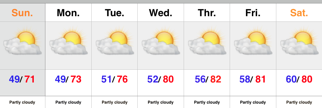
There’s no reason to waste a bunch of pixels on the forecast ahead. High pressure is building in behind the cold front that moved through here Saturday morning. As a result expect dry skies and mostly sunny conditions into next weekend. The cooler, fall-like, air of the weekend will begin to moderate back to summer-like levels into the latter portion of the upcoming work week.
Upcoming 7-Day Rainfall Forecast: 0.00
Permanent link to this article: https://indywx.com/2015/09/19/back-to-a-dry-pattern/
It’s a wet and stormy morning across central IN as a cold front moves through the region. That said, rain will be east of the city by mid to late…
You must be logged in to view this content. Click Here to become a member of IndyWX.com for full access. Already a member of IndyWx.com All-Access? Log-in here.
Permanent link to this article: https://indywx.com/2015/09/19/wet-stormy-start-gives-way-to-a-beautiful-fall-afternoon/
-
Filed under 7-Day Outlook, Autumn, Forecast Discussion, Forecast Models, Rain, Severe Weather, Summer, T-storms, Unseasonably Cool Weather, Unseasonably Warm
-
September 18, 2015
September to date has been drier and warmer than average across the region- right as planned thus far, overall. This morning featured a more aggressive push of showers…
You must be logged in to view this content. Click Here to become a member of IndyWX.com for full access. Already a member of IndyWx.com All-Access? Log-in here.
Permanent link to this article: https://indywx.com/2015/09/18/a-look-where-weve-been-and-where-were-going/
 Highlights:
- Scattered showers around
- Cooler air builds in Saturday
- Still a dry pattern overall
As we wrap up the work week we notice a cold front off to our west. This front will move through the region Saturday morning and will be accompanied by a broken band of showers. More significant showers and thunderstorms will fall across northern IN as that portion of the state will be closer to an area of low pressure. Across central IN, what once will look like an impressive line of showers and thunderstorms will weaken dramatically moving into the area. The front will move through Saturday morning with a notable wind shift and cooler air Saturday afternoon/ evening that will remain into early next week.
Upcoming 7-Day Rainfall Forecast: 0.10″ – 0.25″
Permanent link to this article: https://indywx.com/2015/09/17/cooler-after-a-few-showers/
Another sunny day: This morning’s satellite shows that we’re going to be looking at another mostly sunny and pleasant day across the region. Humidity remains lows for now so it’ll…
You must be logged in to view this content. Click Here to become a member of IndyWX.com for full access. Already a member of IndyWx.com All-Access? Log-in here.
Permanent link to this article: https://indywx.com/2015/09/17/thursday-weather-notebook-3/
-
Filed under AG Report, Autumn, El Niño, Forecast Discussion, Forecast Models, JAMSTEC, snow, Unseasonably Cool Weather, Unseasonably Warm, Winter Outlook, Winter thoughts...
-
September 16, 2015
6:51a, 9.16.15 I tried my best to stay up late enough last night to post this update, but decided to finally turn in after nearly two collisions with me falling…
You must be logged in to view this content. Click Here to become a member of IndyWX.com for full access. Already a member of IndyWx.com All-Access? Log-in here.
Permanent link to this article: https://indywx.com/2015/09/16/updated-jamstec/
 Highlights:
- Dry times continue
- Front comes through mostly dry
- Weekend cooling
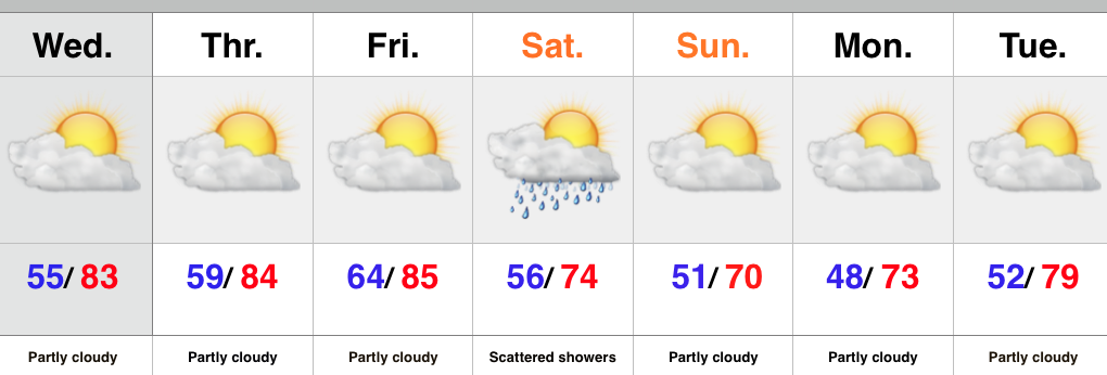
High pressure will remain in control into the latter portion of the work week before giving way to an approaching cold front late Friday. Dry conditions will continue before we introduce showers into the picture late Friday night into early Saturday. Unfortunately this doesn’t appear to be a significant rain maker, but we’ll take what we can get. The bigger story will be the push of much cooler air that arrives Saturday evening into Sunday.
Upcoming 7-Day Rainfall Forecast: 0.10″ – 0.25″
Permanent link to this article: https://indywx.com/2015/09/15/dry-and-warm-now-cooler-times-over-the-weekend/
 Highlights:
- Lots of sunshine
- Rain chances begin to increase late Friday
- Front sweeps the area Saturday with cooler air
We couldn’t have asked for a more glorious beginning to the work week, weather-wise. We hope you had an opportunity to spend some of your Monday outdoors! Thankfully, beautiful weather will prevail into the latter portion of the work week before clouds increase along with shower chances late Friday. This is in association with our next cold front that will move through here Saturday. We’re not looking at signifiant rain with this frontal passage, but another push of cool air will follow Saturday evening into early next week.
Upcoming 7-day Rainfall Forecast: 0.10″ – 0.25″
Permanent link to this article: https://indywx.com/2015/09/14/pleasant-next-front-arrives-at-weeks-end/
-
Filed under AG Report, Autumn, CFSv2, El Niño, Forecast Discussion, JAMSTEC, PNA, SST Discussion, Unseasonably Cool Weather, Unseasonably Warm, Winter thoughts...
-
September 14, 2015
September is still running much warmer than normal, despite the recent well below average regime. See the temperature anomalies over the past (7) days: and the month-to-date: …
You must be logged in to view this content. Click Here to become a member of IndyWX.com for full access. Already a member of IndyWx.com All-Access? Log-in here.
Permanent link to this article: https://indywx.com/2015/09/14/monday-morning-weather-rambles-3/


