July 2015 archive
-
Filed under CFSv2, European Model, Forecast, Forecast Discussion, GFS, Independence Day, Monthly Outlook, Rain, T-storms, Unseasonably Cool Weather
-
July 5, 2015
We hope this finds you coming off an enjoyable Independence Day with friends and family! As we look at the snap shot of the opening to July we see that…
You must be logged in to view this content. Click Here to become a member of IndyWX.com for full access. Already a member of IndyWx.com All-Access? Log-in here.
Permanent link to this article: https://indywx.com/2015/07/05/sunday-morning-catch-up-2/
You must be logged in to view this content. Click Here to become a member of IndyWX.com for full access. Already a member of IndyWx.com All-Access? Log-in here.
Permanent link to this article: https://indywx.com/2015/07/03/4th-of-july-weekend-update-and-looking-at-next-week/
 Highlights:
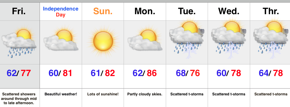
- Scattered showers around today
- Awesome weekend weather on tap
- Dry conditions continue into early next week
- Cold front delivers unsettled weather
A disturbance is moving along a cold front that sits to our south this morning. This will keep scattered showers around central IN through the afternoon hours.
As we move into the holiday weekend we expect the frontal system to sink further south and focus best shower and thunderstorm coverage through the TN Valley. Dry air will move in this evening and set the stage for perfect weekend weather- look for lots of sunshine, comfortable temperatures, and a light northeast breeze Saturday.
Our next weather maker will head our direction early next week in the form of a cold front. Shower and thunderstorm coverage will be on the uptick Tuesday into the mid week period as the front stalls nearby.
Upcoming 7-Day Rainfall Forecast: 0.75″-1″
Permanent link to this article: https://indywx.com/2015/07/03/beautiful-weekend-shaping-up/
 Highlights:
- Lots of clouds, but mostly dry and cooler than normal
- Increasing sunshine for the holiday weekend
- Scattered storm chances increase early next week
While we have considerable cloudiness around, rain chances across central IN will remain few and far between over the next several days (great news)! Better chances of rain and storms will remain across southwestern portions of the state.
We’ll increase our sunshine going into the holiday weekend with only an isolated thunderstorm chance. With the increasing sunshine, temperatures will also be on the rise, but still remain a couple degrees below normal.
Better coverage of showers and thunderstorms can be expected as we roll into early next week.
Upcoming 7-Day Rainfall Forecast: 1″ – 1.5″
Permanent link to this article: https://indywx.com/2015/07/02/mostly-dry-and-cool-looking-nice-for-the-4th/
Just a few thoughts on this Wednesday night… 1.) June officially closed wetter than normal and near average temperature-wise… The Indianapolis National Weather Service posted this earlier today, further…
You must be logged in to view this content. Click Here to become a member of IndyWX.com for full access. Already a member of IndyWx.com All-Access? Log-in here.
Permanent link to this article: https://indywx.com/2015/07/01/wednesday-night-rambles/


