You must be logged in to view this content. Click Here to become a member of IndyWX.com for full access. Already a member of IndyWx.com All-Access? Log-in here.
July 2015 archive
Permanent link to this article: https://indywx.com/2015/07/13/monday-evening-severe-weather-update/
Jul 13
Busy Severe Weather Day…
The Storm Prediction Center continues the Moderate Risk of severe weather for our region today. A busy and potentially dangerous day awaits, including multiple rounds of severe weather, flooding,…
You must be logged in to view this content. Click Here to become a member of IndyWX.com for full access. Already a member of IndyWx.com All-Access? Log-in here.
Permanent link to this article: https://indywx.com/2015/07/13/busy-severe-weather-day/
Jul 12
Sunday Evening Update On Monday’s Weather Situation…
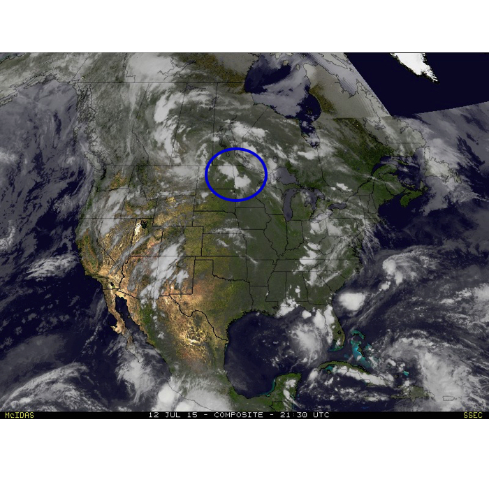 An update this evening shows severe thunderstorms beginning to ignite over the northern Plains. This is all associated with the first in a series of upper disturbances that will move southeast and provide multiple waves of severe weather around our neck of the woods over the upcoming 24-48 hours.
Data this evening really hasn’t changed from what we think will be a potentially dangerous day of severe weather and flooding across central Indiana. It’ll be highly important to remain weather-aware tomorrow and have a means of getting the latest weather information. Please take all warnings seriously. Conditions are highly favorable for numerous damaging wind reports tomorrow and we suggest taking severe thunderstorm warnings as if they were tornado warnings tomorrow because of this.
* Please understand that though some of the data below includes time stamps for reference of what the radar may look like that these storm complexes often take a mind of their own and can accelerate off to the southeast sometimes quicker than what modeled radar may project 12+ hours out. Tomorrow will certainly be a nowcast situation, beginning early in the morning.
With that said, we forecast multiple waves of severe weather tomorrow, beginning in the morning. With high PWAT values, or precipitable water values, thunderstorms will be capable of producing torrential rainfall and flash flooding. It should be noted that with precipitable water values of over 2″ tomorrow (photo below) combined with recent saturated soils, flash flooding is a major concern.
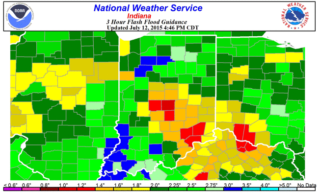
 Speaking of flash flooding, latest data suggests rainfall of only 0.8″-1.5″ within a (3) hr. time period will lead to flash flooding.
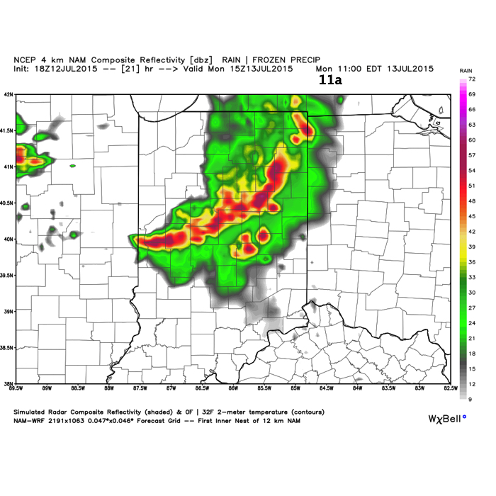
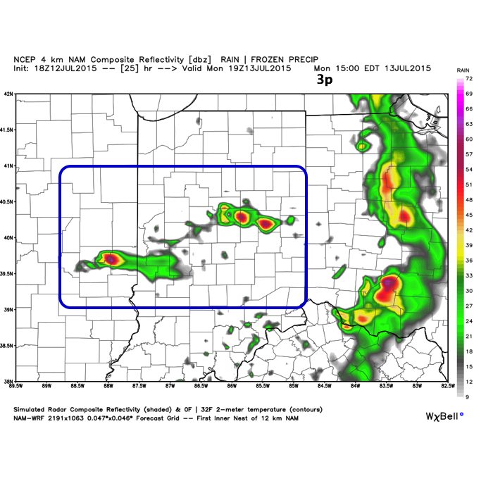
 Again, keeping in mind with the disclaimer prior, here’s what the radar may look like late morning, mid afternoon, and tomorrow night.
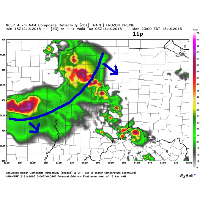 In addition to the aforementioned flash flood concerns, we’re also supremely concerned with the potential of damaging straight line winds, particularly with the 3rd complex of storms Monday evening/ night. Earlier in the day, and depending on how the atmosphere “recovers” with the 1st round of storms Monday morning, conditions are favorable for discrete super cells to develop during the mid afternoon (radar image #2 above). While there are questions, early to mid afternoon would be the most likely time frame for potential tornadic activity and large hail.
To close, please ensure you have a means of getting the latest weather information Monday- beginning early in the morning. Go ahead and charge your phones, tablets, and other electronics. We suggest reviewing your severe weather safety plan with your family this evening to provide a peace of mind, and to ensure you and your loved ones are prepared in the event severe weather and flooding develops.
Permanent link to this article: https://indywx.com/2015/07/12/sunday-evening-update-on-mondays-weather-situation/
Jul 12
Active Pattern; Severe Weather A Major Concern…
- Another round of strong to severe storms rumble in tonight
- Significant severe weather outbreak Monday
- Storms and flood threat continue Tuesday
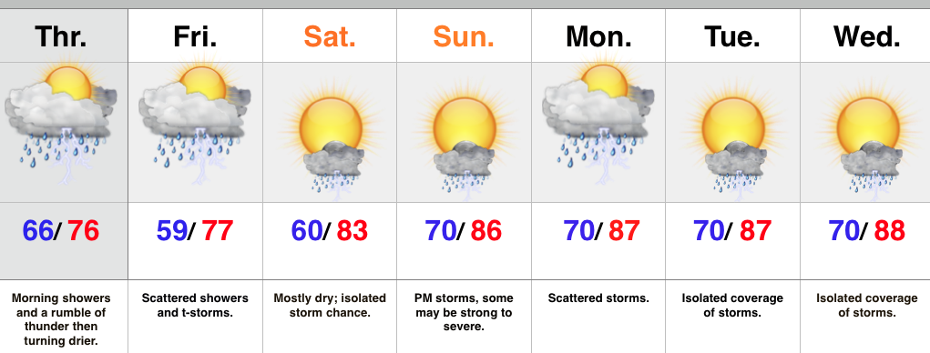
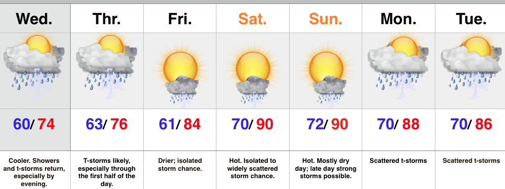
- Drying out and turning hot late week
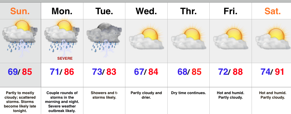
A very active weather pattern will remain through the short-term. Overnight storms have exited to the southeast and we’re now dealing with dry weather and sunshine. A few storms could bubble up this afternoon in the very humid air mass, but the more widespread showers and thunderstorms will hold off until late tonight as another northwest to southeast moving complex rumbles in. Similar to early this morning, flash flooding will be a concern, along with the potential of damaging wind, and hail.
Perhaps more concerning is what we think will be a secondary thunderstorm complex Monday evening into Monday night. Furthermore, conditions appear to favor the threat of a couple super cells developing in advance of the big storm cluster. These individual super cells will have the potential of producing tornadoes and large hail. We’re then concerned of a widespread damaging wind threat with the large storm complex as it moves southeast. Torrential rains and flash flooding will also be a big concern.
Showers and thunderstorms will continue Tuesday, but there’s a light at the end of this wet tunnel by mid week. We forecast a few days of dry weather in the Wednesday through Saturday time period. As ridging expands, heat and humidity will build in a big time way. For those holding out for true summer heat, next weekend may be your time! That said, the long range pattern still supports a wetter/ cooler than normal regime quickly returning so enjoy!
Upcoming 7-Day Rainfall Forecast: 2″-3″ with locally heavier totals
Permanent link to this article: https://indywx.com/2015/07/12/active-pattern-severe-weather-a-major-concern/
Jul 11
Multiple Rounds Of Severe Weather Beginning Sunday…
Good morning and happy Saturday, friends! After a prolonged stretch of clouds, rain, drizzle, and fog, today will feature a good deal of sunshine and very pleasant conditions. Unfortunately, the sunshine and pleasant weather won’t last long as storms and severe weather chances ramp up beginning Sunday, and continues through Monday.
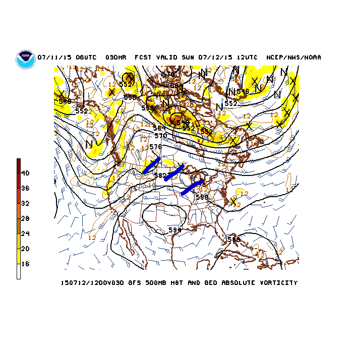
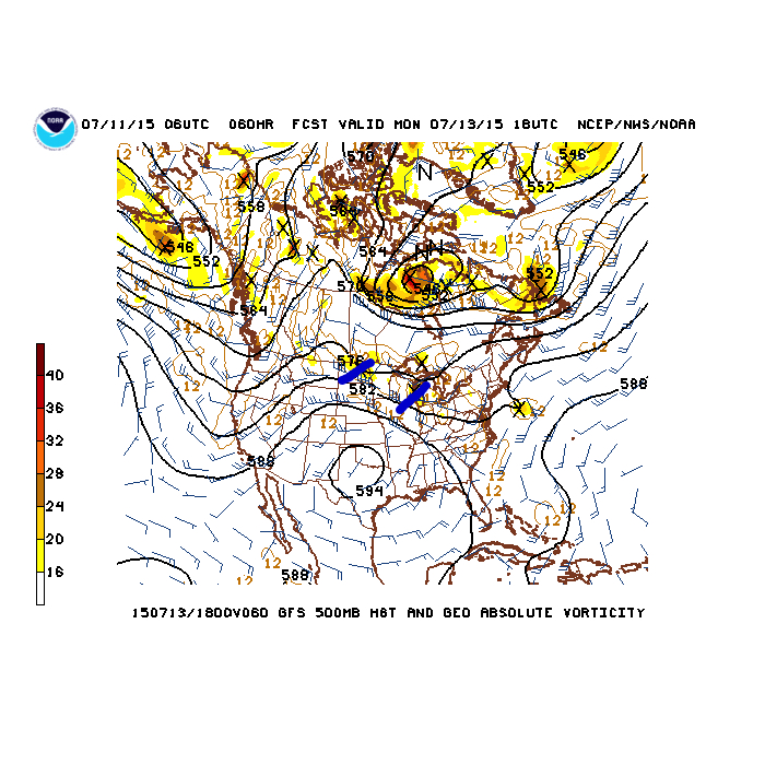
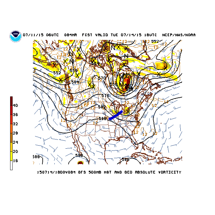
A hot dome (high pressure ridge) will be centered over Texas and this will place our immediate region under a rather busy northwest flow. Multiple disturbances (highlighted in blue below) will rotate northwest to southeast around the periphery of the Texas ridge. Each disturbance will be capable of producing heavy rain and thunderstorms, including severe weather.
Sunday morning
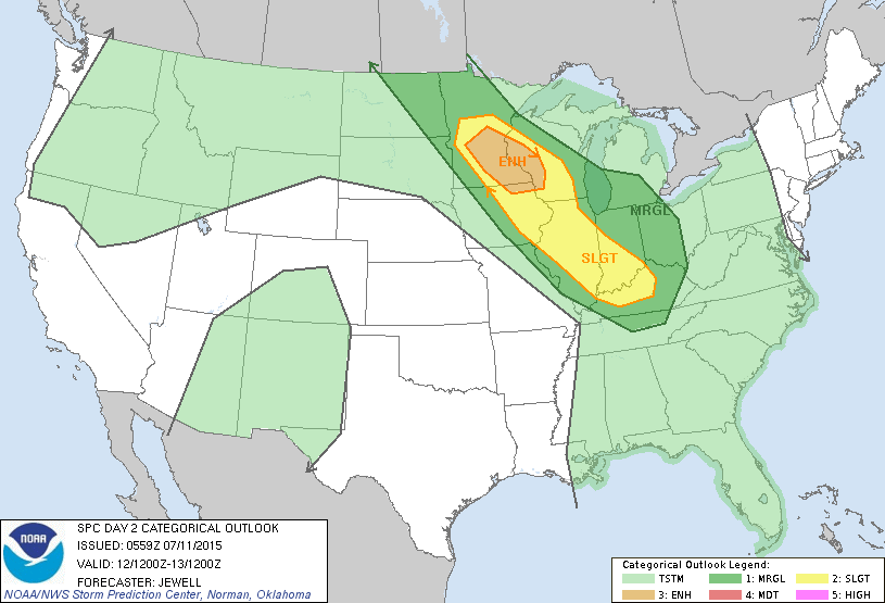
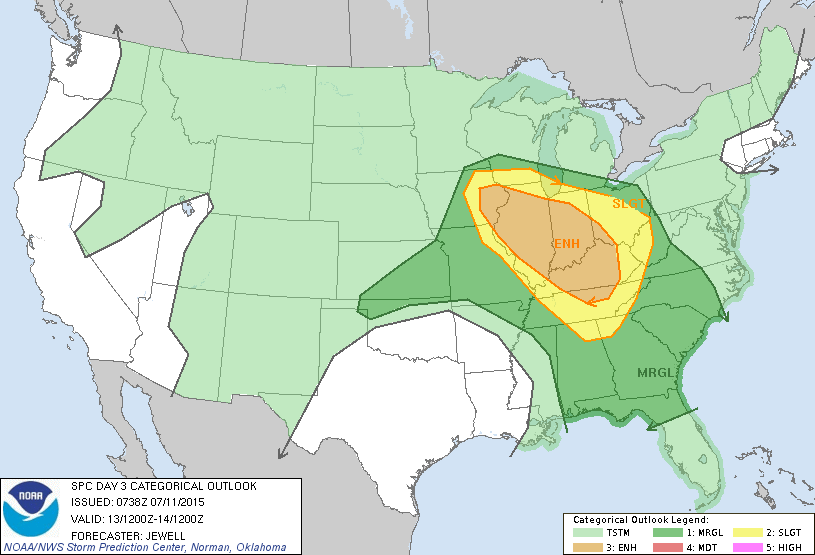
 The Storm Prediction Center has outlined the region for a risk of severe weather both Sunday and Monday, and they mention large hail, widespread damaging wind potential, and isolated tornadoes- particularly with Monday’s event.
Day Two Outlook (Sunday)
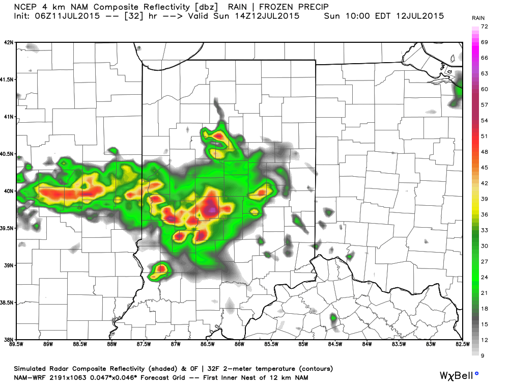
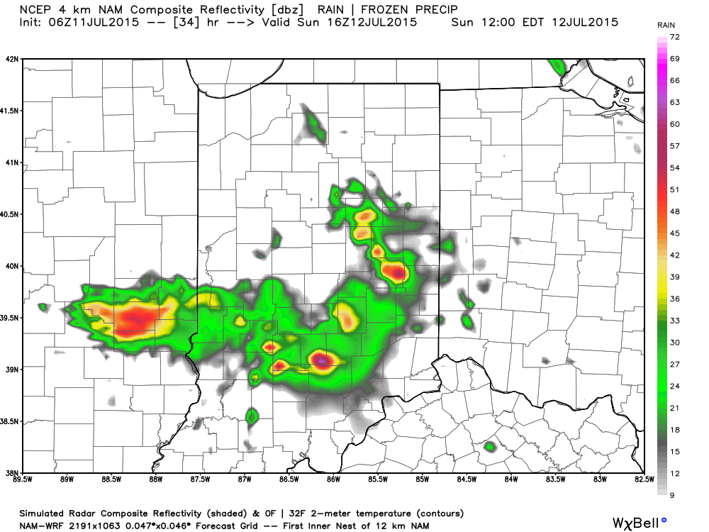
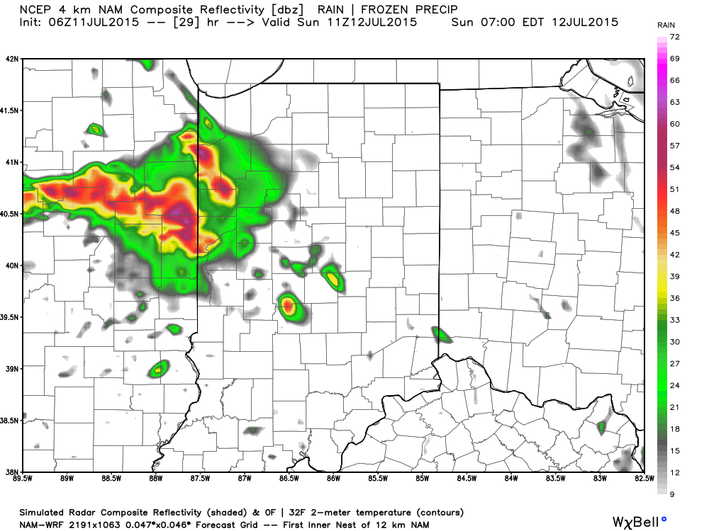
 We’ll begin the action late tonight/ Sunday morning (forecast radar below is a time stamp series from 7a to 12p Sunday) with the first in the expected series of thunderstorms rumbling in from the northwest.
Moral of the story? Enjoy today’s sunshine, but get ready for more active weather in the coming days!
Permanent link to this article: https://indywx.com/2015/07/11/multiple-rounds-of-severe-weather-beginning-sunday/
Jul 10
Same Song And Dance…
Well, here we go again: cloudy skies, rain showers moving in, and cooler than normal temperatures. Another gloomy and wet day is ahead for central Indiana as a couple waves…
You must be logged in to view this content. Click Here to become a member of IndyWX.com for full access. Already a member of IndyWx.com All-Access? Log-in here.
Permanent link to this article: https://indywx.com/2015/07/10/same-song-and-dance/
Jul 09
Turning Drier This Afternoon…
- Wet start turns drier this afternoon
- More sunshine going into the weekend, but we still have storm chances
- Severe weather possible Sunday
- Scattered storms continue next week
Scattered showers remain on the radar this morning, but drier air will work in from the west this afternoon and we may even see some late day sunshine! While we can’t forecast dry weather this weekend, it won’t rain the entire time and periods of sunshine can also be expected. That said, we’ll have to be on the look out for a couple waves of showers and thunderstorms- particularly Friday and again Sunday afternoon/ evening. Those storms Sunday may reach strong to severe levels. As of now, the most isolated coverage of storms looks to come Saturday.
Upcoming 7-Day Rainfall Forecast: 1.5″ -2″ (locally higher totals)
Permanent link to this article: https://indywx.com/2015/07/09/turning-drier-this-afternoon/
Jul 08
More Heavy Rain Inbound Tonight…
You must be logged in to view this content. Click Here to become a member of IndyWX.com for full access. Already a member of IndyWx.com All-Access? Log-in here.
Permanent link to this article: https://indywx.com/2015/07/08/more-heavy-rain-inbound-tonight/
Jul 08
Cloudy, Cool Day; Rain Builds In Later…
We’re off to a cloudy and cool start, but at least things are dry this morning. The frontal boundary that delivered the rain and flooding to central IN Tuesday has…
You must be logged in to view this content. Click Here to become a member of IndyWX.com for full access. Already a member of IndyWx.com All-Access? Log-in here.
Permanent link to this article: https://indywx.com/2015/07/08/cloudy-cool-day-rain-builds-in-later/
Jul 07
More Rain And Storms Ahead…
- Periods of showers and storms through mid week
- Can’t shake weekend storm chances, but drier, and turning hot
- Scattered storms return early next week
A frontal boundary will slip south of central IN later this evening and take most of the heavy rain and storms south tonight into a good chunk of Wednesday. However, the boundary will return north Wednesday evening in response to an area of surface low pressure moving northeast out of the lower and middle MS River Valley. This will return the focus of showers and heavier thunderstorms for our region Wednesday evening into the first half of Thursday. Similar to that of today, locally heavy rainfall is a good bet at times.
The area of low pressure will track east Thursday afternoon and take most of the moisture with it. We’ll forecast drier times to wrap up the work week along with rising temperatures. While we can’t shake weekend storm chances, Friday through Sunday will be drier, overall, when compared to the next couple days. With the heat and humidity around, a few strong to severe storms are possible- particularly Sunday afternoon. We’ll keep an eye on things.
Scattered, “splash and dash,” coverage of storms returns early next week.
Upcoming 7-Day Rainfall Forecast: 2″ – 2.5″
Permanent link to this article: https://indywx.com/2015/07/07/more-rain-and-storms-ahead/

