April 2015 archive

Sun-Filled Weekend; Rain Returns Monday…

Screen Shot 2015-04-11 at 8.01.05 AM
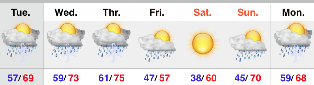
Well Deserved Sunshine…After a week of storms and rain, this forecast should be music to the ears of most Hoosiers.  We forecast both today and Sunday to offer up plentiful sunshine and very pleasant temperatures.  Get out there and enjoy it!

Moisture increases Monday and we’ll introduce showers into the forecast as a southerly flow takes hold in advance of a weak cold front.

Mid week should feature drier conditions before a stronger storm system provides a wet end to the week, complete with thunderstorms Thursday and cooler, more showery weather Friday.

Upcoming 7-Day Precipitation Forecast:

  • 7-Day Rainfall Forecast: 0.75″ – 1.00″
  • 7-Day Snowfall Forecast: 0.00″

Permanent link to this article: https://indywx.com/sun-filled-weekend-rain-returns-monday/

Cooler Pattern Developing Week 2…

After a warm open to April, we note the MJO is heading into Phase 2 in the medium range.  Phase 2 this time of year would imply for a cooler than normal pattern.

ECMF_phase_51m_small


combined_imageSure enough we see the modeling going towards the cooler look for Week 2 (around 4/17…give or take a day, or two).

Note the GFS ensembles reverse course towards a cooler regime after the warm period currently.

1


2


The European ensembles (left) show a tendency for eastern troughiness, as well.

Geopotential32at32500hPa_North32America_216This isn’t saying some sort of record-smashing cold pattern is coming or anything of that sort, but it is to say that after a warm open to April, we’ll reverse things for a few days, at least, during the medium range period.  This could include a push of frost and freeze conditions, as well.

In the shorter-term, please remain weather aware tonight and keep close tabs on watches and warnings issued by the National Weather Service.  Thunderstorms should push into central Indiana around midnight and will be capable of severe levels, including damaging hail, destructive straight line winds, and quick spin-up tornadoes.

Permanent link to this article: https://indywx.com/cooler-pattern-developing-week-2/

Severe Weather Thursday; Nice Weekend Coming…

Screen Shot 2015-04-08 at 9.13.14 PMStay Weather Aware…As we type this central Indiana is enjoying a brief lull in what’s been a rather active day, complete with strong to severe thunderstorms.  Latest scans of our short term forecast models suggest the quiet times don’t last long as more thunderstorms rumble into central Indiana during the overnight hours.  Hail, vivid lightning, and additional flooding is possible with overnight/ early Thursday morning storms.

Attention then shifts to the possibility of a rather significant severe weather outbreak Thursday afternoon into Thursday night, particularly if we get rid of morning convection and cloud debris.  Tonight’s data would suggest we do clear things out Thursday afternoon and this would add “fuel to the fire” for potential severe weather Thursday night.  All modes of severe weather are in play Thursday night, including large hail, damaging straight line winds, and tornadoes.  Flash flooding will also remain a concern as some areas have accumulated more than 3″ of rain today alone.

The cold front and associated surface low responsible for Thursday’s severe weather will sweep the state Friday and usher in a much cooler and breezy regime Friday evening that will continue into Saturday.  Sunshine returns in full force Saturday and Sunday.  Perfect timing, huh?!

Enjoy that sunshine and calmer times of the weekend as rainy and stormy conditions return quickly early next week.  All-in-all, the overall theme remains a warm, wet, and stormy one.

Upcoming 7-Day Precipitation Forecast:

  • 7-Day Rainfall Forecast: 2.50″ – 3.00″
  • 7-Day Snowfall Forecast: 0.00″

Permanent link to this article: https://indywx.com/severe-weather-thursday-nice-weekend-coming/

Busy 48 Hours Ahead…

A very busy 48 hours lies ahead with multiple storm clusters that will traverse the region. Severe weather will be possible with each storm complex and torrential downpours may lead…

You must be logged in to view this content. Click Here to become a member of IndyWX.com for full access.  Already a member of IndyWx.com All-Access?  Log-in here.

Permanent link to this article: https://indywx.com/busy-48-hours-ahead/

Warm And Stormy…

Screen Shot 2015-04-07 at 7.46.54 AMKeep The Rain Gear Handy…A stationary boundary remains draped across the Ohio Valley and will serve as the focal point for scattered showers and thunderstorms through Wednesday.  Some of the storms may be strong and include torrential downpours.  That said, there will be many dry hours, as well.

We shift our focus to the chance of severe weather Thursday as surface low pressure moves into the Great Lakes and swings a cold front into a warm, humid, and relatively unstable air mass locally.  As of now, damaging straight line winds and large hail are the biggest concerns, but there’s also the chance of a tornado.  Stay tuned.

After an early shower Friday, we’ll clear things out nicely to wrap up the work week and head into the weekend.  Friday will be much cooler, but that April sun will help temperatures recover quickly Saturday.  Most of Sunday will be dry, but we’ll introduce showers Sunday evening.  This will set up a stormy open to next week.

Upcoming 7-Day Precipitation Forecast:

  • 7-Day Rainfall Forecast: 2.00″ – 2.50″
  • 7-Day Snowfall Forecast: 0.00″

Permanent link to this article: https://indywx.com/warm-and-stormy/