January 25, 2015 archive
First, I just want to take a moment to thank each and every one of our viewers. Your support of what we’re doing here is incredible and, at times, truly…
You must be logged in to view this content. Click Here to become a member of IndyWX.com for full access. Already a member of IndyWx.com All-Access? Log-in here.
Permanent link to this article: https://indywx.com/2015/01/25/a-word-of-thanks/
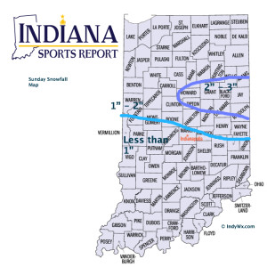
 High Bust Potential Today…Clippers are always tough to forecast, but particularly so today. This is a vigorous system and while temperatures will only be marginally cold, the concern here is that precipitation rates may help cool the entire column of air a bit quicker this afternoon than modeling currently suggests. If (big if) that’s the case, then snowfall amounts below would have to be increased. As it is now, we feel about as confident as we can be right now that the “slimmed” down numbers below will suffice. As has been the case with a couple of other events this winter, it’ll be a nowcast scenario this afternoon. Winds will also become quite gusty out of the east and northeast this afternoon into tonight.
Colder, drier air builds in late tonight and Monday before a weak weather system scoots through and delivers light snow showers Tuesday. A wintry mix is possible Thursday and then we’ll eye late next weekend for the next snow opportunity.
Upcoming 7-Day Precipitation Forecast:
- 7-Day Snowfall Forecast: 2″ – 4″
- 7-Day Rainfall Forecast: 0.50″

Permanent link to this article: https://indywx.com/2015/01/25/tough-forecast-today/


