January 21, 2015 archive

Colder, But Nothing Drastic…

Screen Shot 2015-01-21 at 6.28.17 PM

Colder, But Nothing Too Out Of The Ordinary…A colder theme will be with us as we put a wrap on the work week.  That said, temperatures will actually be much closer to where they should be for this time of the year.  A quiet weather pattern will continue until we watch a clipper system for the second half of the weekend.  As of now, the accumulating snow looks to stay north of our immediate region, but we’ll keep a close eye on it.  Officially, we’ll call for increasingly cloudy skies Saturday night into Sunday morning with scattered rain showers Sunday afternoon changing to snow showers Sunday night before ending. If traveling north, prepare for several inches of snow across northern portions of the state into the Great Lakes region.  Stay tuned as this system is still a few days off and changes can take place moving forward.  Colder air follows for early next week.

Upcoming 7-Day Precipitation Outlook:

  • 7-Day Rainfall Forecast: 0.10″ – 0.20″
  • 7-Day Snowfall Forecast: Dusting

Permanent link to this article: https://indywx.com/2015/01/21/colder-but-nothing-drastic/

Facts Are Facts…

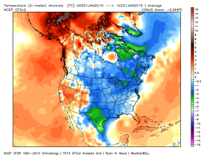
I’m hearing rumblings out there that you can’t get sustained cold across Indiana without a negative Arctic Oscillation (AO) and/ or negative North Atlantic Oscillation (NAO).  I would ask those with that belief to please explain the following:

January temperature anomalies month-to-date show widespread cold (even accounting for the January thaw the past week).

ncep_cfsr_noram_t2m_anom


The first two weeks of the month were downright frigid and this was in the face of an AO that was not just positive, but strongly positive.

AO

To take this a step farther, the recent relative warmth has come with a negative AO.

Bottom line is that a ton of drivers are trying to take the wheel this winter.  Admittedly, that makes things incredibly difficult for forecasting- short-term or longer range.  That said, coming out with a “blanket statement” that you can’t have sustained cold without a negative AO or NAO is a flat-out lie and we wanted to address it.  Teleconnections can help many times with coming weather patterns, but not always.  This winter is a prime example of that.

Quick note on the clipper system- all forecast models today have taken the primary impacts (at least from a snow standpoint) north of the immediate region (central Indiana). Heaviest snows are favored across the Great Lakes, extending down into northern IN. We’ll continue to keep a close eye on things…

Permanent link to this article: https://indywx.com/2015/01/21/facts-are-facts/

Light Rain And Snow Showers Around This Afternoon/ Evening…

Scattered light rain and snow showers will dot the central Indiana landscape this afternoon and evening as colder air moves into the region.

hrrr_ref_indy_14

Thursday and Friday will be colder than what we’ve been used to the past few days, but nothing out of the ordinary and actually more seasonal.

We’re still eyeing a late weekend clipper system, but the precise track will determine who sees “several” inches of snow, versus little to nothing. Feast or famine, we’ll call it!  Overnight computer model guidance would place the heavier snow totals across northern portions of the state, but we still have a ways to go before anything is set in stone.

Back later this evening with a complete 7-day update!

Permanent link to this article: https://indywx.com/2015/01/21/light-rain-and-snow-showers-around-this-afternoon-evening/

IndyWx.com