I apologize for the lack of posts today. My wife and I took time to get away for the weekend before the busy winter weather invades. As a side note- it takes a special woman to put up with someone like me who has to check each and every model run through the day (and night). I have an internal clock that causes me to wake up for the European run between 1a – 2a every night this time of year (pathetic, I know). At any event, here are some of the quick-hitting bullet point highlights of what’s ahead into mid week:
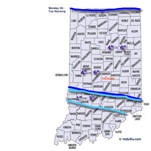
- Plowable Snow: Snow arrives into central IN by mid to late evening Monday and falls fast and furious for a few hours during the overnight. Thinking here is that the majority of accumulating snow will fall after the evening rush Monday and before the morning rush Tuesday. That said, it’ll be tough for snow removal companies and plows to keep up during the heart of the storm as snowfall rates will likely top 1″/hr during the overnight Monday. Tuesday’s rush to and from work won’t be fun. The snowfall map above is our best educated idea at this point, but we also think a localized band of 7″ – 8″ totals can’t be ruled out and we’ll use tomorrow to fine tune that band (early thinking is just north of the city).
- Strong Winds: We’re still expecting wind and cold to become a huge story and concern Tuesday afternoon into mid week. Northwest winds will become strong and gusty Tuesday and result in considerable blowing and drifting of snow (especially by afternoon). Travel will likely remain difficult because of the combination of blowing, drifting, and the bitterly cold air. Wind speeds will top 20-30 MPH Tuesday afternoon and night as the arctic front blows through.
- Dangerous Cold: Temperatures will plummet Tuesday afternoon as the arctic air hits like a “wall.” This will set the stage for dangerously cold air Tuesday night through Thursday, including below zero temperatures (5-10 below zero) and wind chill values that approach 30 degrees below zero. Temperatures Wednesday will struggle to make it much above zero for the high (not a typo).


