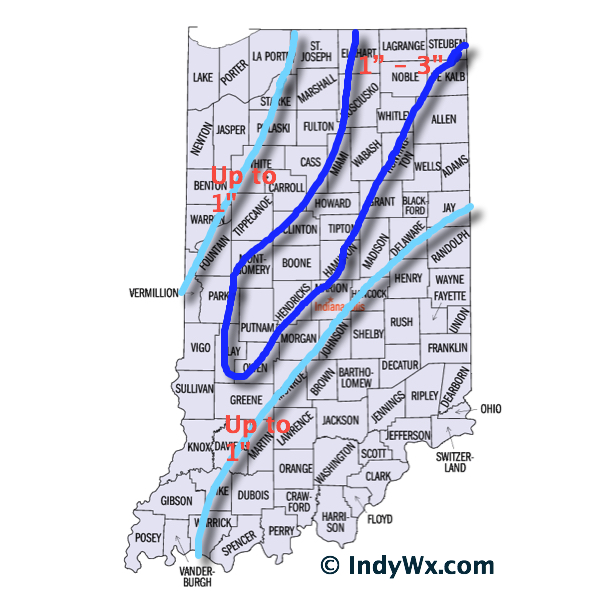
In what’s been an agonizing 6-7 days it’s only fitting that this will come down to the very end. Model performance has been poor, at best, concerning our Christmas Eve storm and given many forecasters a gray hair or two (yours truly included).
We’re going to lay out our best thinking below, but I want to be very clear when I say that we’re in a “now cast” mode for the rest of the day. It’ll be particularly important to have a means of gathering the latest weather information if you have travel plans later today.
Overnight model data shifted the track of a developing surface low east. After looking over all of the available data, we now have converged on a surface low track that moves northeast from west Tennessee into northwest Ohio. The surface low will strengthen as it moves northeast, helping wrap cold air into the system and change rain to a wet snow across central Indiana this afternoon and evening.
The tricky part comes into play when we get into the details. Banding features and associated precipitation rates will be key in determining when local communities see a transition to wet snow and ultimately how much accumulates. This won’t be a “uniform” type accumulation event. Dynamics with this system are impressive, despite only marginally cold air. If we get into a situation where heavier banding develops it won’t take long to cool the entire column of air and result in localized moderate to heavy snow.
On the flip side, surface temperatures are mild after a day yesterday into the middle 50s. Add in the fact stated above of only marginally cold air available and precipitation intensity will be key. If precipitation isn’t heavy enough, it’ll be tough for much snow to fall, yet alone accumulate.
Bottom Line:
As stated above, this is a now cast scenario through the rest of your Christmas Eve. Given all of the data we’ve looked at, this is how we see things playing out this evening:
- Rain falls through the morning hours
- Rain begins to first mix with and transition to snow across west-central Indiana between 12p-2p
- Snow begins falling across most of central Indiana by 3p-4p
- Snowfall could be locally heavy within localized banding that sets up. If this is the case, snowfall rates would be heavy enough to overcome relatively mild road surfaces and create travel issues.
- Snow diminishes to flurries by 8p
- Winds will gust in excess of 30 MPH this afternoon and evening

