March 2014 archive

Warmest Day Of The Period…

Fri.

Sat.

Sun.

Mon.

Tue.

Wed.

Thr.

 Status-weather-showers-day-icon

 Status-weather-showers-day-icon

 Status-weather-clouds-icon

 Status-weather-clouds-icon

 Status-weather-snow-scattered-icon

 Status-weather-clouds-icon

 Status-weather-clouds-icon

36/ 63

31/ 47

26/ 39

21/ 37

26/ 36

19/ 38

28/ 54

Light

Light

– – –

– – –

Light

– – –

– – –

Forecast Updated 03.21.14 @ 7:50a

Warm Front Passes. . .A warm front lifted north through the state during the wee morning hours. This sparked a couple light showers (snow burst across northern portions of the state), but wasn’t a big deal and a very nice Friday is on tap.  We’ll note a strong and gusty southwest breeze in play that will help send temperatures into the lower to middle 60s for afternoon highs along with partly cloudy skies.

Here Comes The Cold. . .Just as quick as the warm front passes a cold front will swing through the region and put an abrupt end to the spring tease.  Unfortunately, temperatures will slide the wrong direction over the weekend along with strong and gusty northwest winds.  This front may be accompanied by a couple light showers late tonight into early Saturday.

Tuesday Snow Maker. . .After a cold, but dry open to the work week, a disturbance will cross the Ohio Valley Tuesday and provide just enough moisture to combine with the cold air in place to result in the likelihood of light snow around these parts Tuesday.  We’re not thinking much in the way of accumulation will occur as overall snowfall rates will be relatively light, but we do note some localized light accumulations are possible. Otherwise, expect a mostly cloudy and “ridiculously” cold day.

Moderating. . .Indications are that we’ll begin to enjoy the return of southwest (milder) breezes in here by the end of next week.  As such, temperatures will begin to moderate and perhaps “inch” above the 50 degree mark by next Thursday.

Upcoming 7-Day Precipitation Forecast:

  • 7-Day Rainfall Forecast: 0.10″ – 0.25″
  • 7-Day Snowfall Forecast: Less than 1″

twicFor weather updates and more “behind the scenes” data on the go, be sure to Follow Us on Twitter @indywx or become a Friend of IndyWx.com on Facebook!

images

Permanent link to this article: https://indywx.com/2014/03/20/warmest-day-of-the-period/

Sunshine Returns!

Thr. Fri. Sat. Sun. Mon. Tue. Wed.               27/ 52 35/ 63 31/ 47 28/ 39 21/ 37 25/ 36 20/ 38 – –…

You must be logged in to view this content. Click Here to become a member of IndyWX.com for full access.  Already a member of IndyWx.com All-Access?  Log-in here.

Permanent link to this article: https://indywx.com/2014/03/20/sunshine-returns/

Video Update On The Next Couple Weeks!

Here’s a rather lengthy video taking a look at the weather here across central Indiana the next couple weeks. Oh yeah, we’re also a little excited about Coach Pearl coming…

You must be logged in to view this content. Click Here to become a member of IndyWX.com for full access.  Already a member of IndyWx.com All-Access?  Log-in here.

Permanent link to this article: https://indywx.com/2014/03/19/video-update-on-the-next-couple-weeks/

Busy Weather Week. . .

Tue.

Wed.

Thr.

Fri.

Sat.

Sun.

Mon.

 Status-weather-clouds-icon

 Status-weather-showers-day-icon

 Status-weather-clouds-icon

 Status-weather-showers-day-icon

 Status-weather-showers-day-icon

 Status-weather-clouds-icon

 images

28/ 55

37/ 49

29/ 53

40/ 62

31/ 46

22/ 35

21/ 40

– – –

Light

– – –

Light

Light

– – –

– – –

Forecast Updated 03.18.14 @ 7:57a

Nice Tuesday. . .Clouds hung tough Monday, but we finally got into sunshine during the afternoon which led to a very pleasant, albeit chilly, Monday evening.  Thankfully, the sunny close to Monday was a precursor to what we can expect Tuesday- mostly sunny to partly cloudy.  We’ll note a big improvement in the temperature department (after another cold start), courtesy of an increasingly strong south wind through the day.

Windy Wednesday. . .A cold front will race through the region Wednesday morning and will be accompanied by a band of showers and embedded thunder.  We think the majority of the rain falls during the predawn/ early morning hours Wednesday and most of the daylight hours will be dry, colder, and very windy.  A tightly wound low pressure system will roar through the Great Lakes region Wednesday and be responsible for producing strong and gusty winds, including gusts upwards of 40 MPH during the day Wednesday.

Thursday will be an “in between” day that will include dry skies and moderating temperatures.

Another Fast Moving Storm System. . .Yet another frontal boundary will blow through the region late Friday night and Saturday morning.  Before hand, a warm front will lift north through the region Friday morning and could help spark a scattered shower as it lifts north.  That said, most of the day will be dry and include an increasing south wind that will assist in shooting temperatures into the lower to middle 60s Friday afternoon.  Clouds will once again increase Friday night and lead to showers Friday night into Saturday morning.

Turning Colder Over The Weekend. . .A colder air mass will pour into the region for the upcoming weekend as north winds blow yet again.  This will send temperatures to well below normal levels.  In fact, temperatures will likely fall through the day Saturday, and Sunday will be another blustery, cold day.

As we look ahead to early next week, there will be a system that will warrant our attention for possible rain and/ or snow, but it’s far too early to be specific with this event.  Just know that we’ll keep our eye on things.  Regardless, conditions will be much colder than normal to put a wrap on March… Hang in there, spring has to arrive eventually, correct?

Upcoming 7-Day Precipitation Forecast

  • 7-Day Snowfall Forecast: 0.00″
  • 7-Day Rainfall Forecast: 0.25″-0.50″

twicFor weather updates and more “behind the scenes” data on the go, be sure to Follow Us on Twitter @indywx or become a Friend of IndyWx.com on Facebook!

images

Permanent link to this article: https://indywx.com/2014/03/17/busy-weather-week/

Changeable Weather This Week…

Mon.

Tue.

Wed.

Thr.

Fri.

Sat.

Sun.

 Status-weather-clouds-icon

 Status-weather-showers-day-icon

 Status-weather-clouds-icon

 Status-weather-clouds-icon

 Status-weather-showers-day-icon

 Status-weather-clouds-icon

 Status-weather-clouds-icon

19/ 43

30/ 56

35/ 50

30/ 51

42/ 65

30/ 45

22/ 37

– – –

Light

– – –

– – –

Light

– – –

– – –

Forecast Updated 03.17.14 @ 12:00p

Quiet, Brighter Start To The Work Week. . .After a “ridiculously” cold, windy, and gloomy Sunday, it’ll be nice to see the sunshine return as we kick off another work week.  Temperatures will remain much colder than average, but with that late March sun working through later this afternoon (once these pesky clouds move east), it’ll feel somewhat better.

Fast Moving Storm System. . .Most of Tuesday will be sunny and dry, but a frontal boundary will race towards central Indiana Tuesday evening and we note some of our high resolution model data trying to bring a thin line of showers and thunderstorms through in association with this frontal passage.  After a mainly dry day, clouds will increase and we’ll forecast quick-moving showers and embedded thunder Tuesday night into Wednesday morning.  Rainfall amounts will remain light.

Dry, blustery weather will return Wednesday afternoon with temperatures just a few degrees below normal.

Late Week Storm. . .After a dry and pleasant Thursday, southwest breezes will kick into high gear and allow temperatures to jump into the middle to perhaps upper 60s Friday (dependent upon how much sunshine we see).  That said, another cold front will have it’s eyes set on our area and clouds will increase during the afternoon and evening hours with showers and thunderstorms developing Friday night as the front pushes southeast.

This will then set the stage for another cold weekend ahead.  While we’re trending next weekend (especially Sunday) MUCH colder, it’s possible we’ll have to lower temperatures even further in the days ahead.

Upcoming 7-Day Precipitation Forecast:

  • 7-Day Snowfall Forecast: 0.00″
  • 7-Day Rainfall Forecast:  0.25″

twic

For weather updates and more “behind the scenes” data on the go, be sure to Follow Us on Twitter @indywx or become a Friend of IndyWx.com on Facebook!

images

After a long winter, sunshine and pleasant temperatures provided a great day to get outside and enjoy the conditions last Saturday in Zionsville!  Thanks to John Salewicz for this shot!

photo-2

Permanent link to this article: https://indywx.com/2014/03/16/changeable-weather-this-week/

Much Colder And Very Windy Sunday

The storm system that looked like it may provide central Indiana accumulating snow earlier this week is, indeed, remaining south. Portions of southern parts of the state will see light…

You must be logged in to view this content. Click Here to become a member of IndyWX.com for full access.  Already a member of IndyWx.com All-Access?  Log-in here.

Permanent link to this article: https://indywx.com/2014/03/16/much-colder-and-very-windy-sunday/

Dry Today; Windy And MUCH Colder Sunday…

Sat.

Sun.

Mon.

Tue.

Wed.

Thr.

Fri.

 Status-weather-clouds-icon

 images

 Status-weather-clouds-icon

 Status-weather-showers-day-icon

 Status-weather-clouds-icon

 Status-weather-clouds-icon

 Status-weather-clouds-icon

32/ 52

24/ 30

17/ 42

27/ 54

39/ 50

32/ 53

33/ 62

– – –

– – –

– – –

Light

– – –

– – –

– – –

Forecast Updated: 03.15.14 @ 8:53a

Nice Today; MUCH Colder Sunday. . .Today will easily be the pick of the weekend as mostly sunny skies dominate along with seasonable temperatures.  Get outside and enjoy!

We continue to watch a southern storm system for the second half of the weekend and while model data trended north Thursday, the common theme most of Friday into this morning has been back south.  As such, we’ll lean towards a less snowy forecast Sunday for central Indiana, but note if you have travel plans to the southern third of the state that accumulating snow and ice will greet you Sunday.  Here across central Indiana look for a rather cloudy and MUCH colder day.  In fact, temperatures won’t even make it to the freezing mark with a very strong east to northeast wind in play.  Winds may gust as high as 35 MPH Sunday afternoon, making it feel like the single digits and teens.

Relatively Quiet Week. . .Modeling continues to struggle with the timing and strength of storm systems in the week ahead, but current thinking takes the storm track primarily north of our area next week, meaning less impact (from rain or snow chances) here.  We caution that this can change and we’ll keep a close eye on things, but we’re trending our forecast towards a quieter one for now.  The next system of note will be a fast moving low pressure area and associated cold front that will pass here Tuesday into Wednesday.  A scattered shower and wind shift will occur with this system, but, as stated above, the majority of the more significant “weather” will lie to our north.

A brief warming trend to well above normal temperatures may carry us to close out the work week before the next systems eyes our area later next weekend.

Upcoming 7-Day Precipitation Forecast

  • 7-Day Snowfall Forecast: 0.00″
  • 7-Day Rainfall Forecast: 0.25″

twic

For weather updates and more “behind the scenes” data on the go, be sure to Follow Us on Twitter @indywx or become a Friend of IndyWx.com on Facebook!

images

I know many are saying thankfully we aren’t dealing with this kind of weather today.  After a harsh winter, it’s always nice to see the sunshine and milder temperatures return.  Today we take you back to a snowy Zionsville from February 17th.  This shot was taken by Janet Baker.  Thanks, Janet!

SnowFeb17Zionsville

Permanent link to this article: https://indywx.com/2014/03/15/dry-today-windy-and-much-colder-sunday/

Spring Like Today, But Keeping A Close Eye On Sunday…

Fri.

Sat.

Sun.

Mon.

Tue.

Wed.

Thr.

 Status-weather-showers-day-icon

 Status-weather-clouds-icon

 Status-weather-snow-scattered-icon

 Status-weather-clouds-icon

 Status-weather-showers-scattered-icon

 Status-weather-snow-scattered-day-icon

 Status-weather-clouds-icon

32/ 60

32/ 52

24/ 34

19/ 36

32/ 48

30/ 40

28/ 45

Light

– – –

Moderate

– – –

Light

Light

– – – 

Forecast Update 03.14.14 @ 7:45a

Nice Close To The Work Week. . .A weak frontal system will blow through the region later this afternoon and this may spark a light shower south and east of the city.  All in all, it won’t be a big deal and won’t put a damper on an otherwise beauty of a close to the work week.  Gusty southwest winds will help temperatures zoom into the upper 50s to near 60 for afternoon highs.

Sunday Snow Storm Brewing?  That’s the big question this morning.  Model data continues to trend north and west with this storm system and we’re keeping a close eye on things.  The set up is one that features a late season arctic high over the Great Lakes region Sunday with developing low pressure moving out of Texas and into the TN Valley.  Yes, we’ll have the cold and the moisture…

We know Sunday will be a MUCH colder and windy day, but we’re trending our forecast snowier, as well.  Best chances of snow arrive Sunday afternoon into Sunday night.  While there’s still some question in regards to the northern extent of the snow shield, the northwest trend may not be done just yet.  As a result, we feel central Indiana is very much in play for accumulating snow Sunday afternoon through Sunday night.  Stay tuned.

Another Storm. . .Another storm system will arrive Tuesday into Wednesday and modeling continues to struggle on this event, as well.  We’ll leave the forecast relatively unchanged for Tuesday and Wednesday now.  After we deal with Sunday we’ll be able to get a better handle on the Tuesday/ Wednesday storm system.

Upcoming 7-Day Precipitation Forecast

  • 7-Day Snowfall Forecast: 2-4″
  • 7-Day Rainfall Forecast:  0.25″

twicFor weather updates and more “behind the scenes” data on the go, be sure to Follow Us on Twitter @indywx or become a Friend of IndyWx.com on Facebook!

images

John Salewicz sent in this beautiful panoramic cloud shot from Zionsville Thursday evening.  Thanks, John!

Photo

Permanent link to this article: https://indywx.com/2014/03/14/spring-like-today-but-keeping-a-close-eye-on-sunday/

70 Degree + Type Weather Coming?

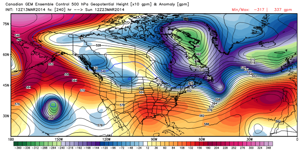
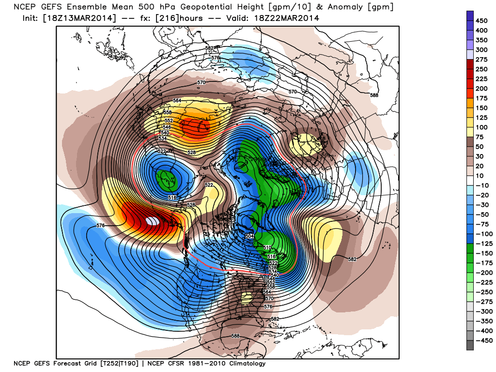
While we remain in a overall colder than normal pattern, spring, obviously, has to get here one day, right?!  The past week has seen an increase in spring at least “flirting” with the region for brief 24-36 hour time periods and this will continue over the upcoming week.

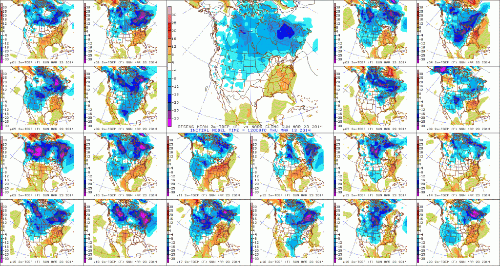
We remain concerned about a potential shot of well below normal cold to open April, but we thought it would be nice to talk about something pleasant for a change.  🙂  We’re keeping a close eye on next weekend, March 22nd and 23rd, for the potential first 70 degree + type day at IND this year.

The latest ensembles aren’t shying away from a significant, though transient, ridge building in during this time period.

12

Note the GFS showing the transient, though significantly, warmer than normal air that would likely occur in this type pattern.  70 degrees + would certainly be attainable.

3

See, we don’t just provide doom and gloom (though this past winter may seem that way) at IndyWx.com!

Permanent link to this article: https://indywx.com/2014/03/13/70-degree-type-weather-coming/

A Look At Friday And A Comment On Sunday…

Good evening.  We wanted to touch base on a couple of things this evening.  Details are in the video…

You must be logged in to view this content. Click Here to become a member of IndyWX.com for full access.  Already a member of IndyWx.com All-Access?  Log-in here.

Permanent link to this article: https://indywx.com/2014/03/13/a-look-at-friday-and-a-comment-on-sunday/

IndyWx.com