February 28, 2014 archive

Some Late Night Thoughts…

It’s been a long day, but we’d like nothing more than to be right here in the good ole forecast office, digging into data for our next winter storm with you.  While “part 2” of the storm remains just offshore as of this post, it’ll likely be trudging onshore by the time you read this early Saturday morning.  That said, the initial wave of accumulating snow (and for some, ice) will arrive as early as late Saturday night/ wee morning hours (well before sunrise) Sunday in the form of an overrunning event- where comparably warmer, more moist air is lifted up and overruns the cold air at the surface.

Early ideas suggest we undergo a period of moderate to heavy wintry precipitation as early as 3-ish Sunday morning, extending into the late morning hours.  Particularly, we bracket the hours of 3am to 10am Sunday for the initial wave of wintry weather.  This will be a mixed bag of precipitation, including snow, sleet, and freezing rain across central Indiana.  An early look at the high resolution simulated radar courtesy of the NAM shows this well- valid 7am Sunday morning.  Image is courtesy of the fine folks over at Weatherbell Analytics.

hires_ref_indy_37

After a “lull” in the accumulating wintry precipitation from late morning/ early afternoon Sunday, we’ll likely deal with another round of moderate to heavy accumulating wintry precipitation Sunday afternoon into Sunday night.  It’s important to note this is where we have more questions than answers in regards to the interaction of a juiced up southern stream of the jet- infused by the powerhouse late season winter storm (still spinning just off shore as of this update).  Powerful arctic high pressure will be sinking south and could result in a more suppressed track of the low. Should this be the correct scenario snow totals would likely be towards the lower end of the ongoing 6-8″ forecast we hoisted back on Thursday morning.  That said, one can’t ignore the pattern as it’s one notorious for heavy snow producers across central Indiana.  A scan over heavy snow events of the past here across central Indiana show similar setups that have yielded impressive snow totals.  Just as the potential of suppression has to be noted, so should the potential of a slightly more north trend that models may currently see as time gets closer.

In closing tonight, 12z model data should really begin to hone in on the area most likely to see heaviest snow and/ or ice accumulations.  Our ongoing forecast of storm totals remains unchanged for now of 6-8″.  Stay tuned, friends.

Permanent link to this article: https://indywx.com/2014/02/28/some-late-night-thoughts/

More On This Weekend’s Winter Storm…

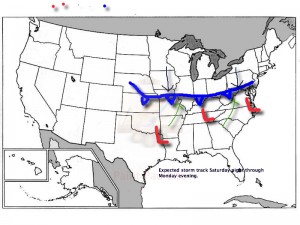
As we’ve been discussing, a significant winter storm is developing this weekend.  The set up is one that will feature an arctic cold front sinking south and stalling out across southern and central Indiana Saturday night.  Low pressure will then organize over the Ark-la-tex region and head northeast, tracking into the northern Tennessee Valley Sunday and Sunday night.  The low will move off the southern Mid Atlantic coastline Monday evening.  This will be more of a prolonged event when compared to our last two winter storms as waves of moderate to heavy snow move into central Indiana beginning late Saturday night.

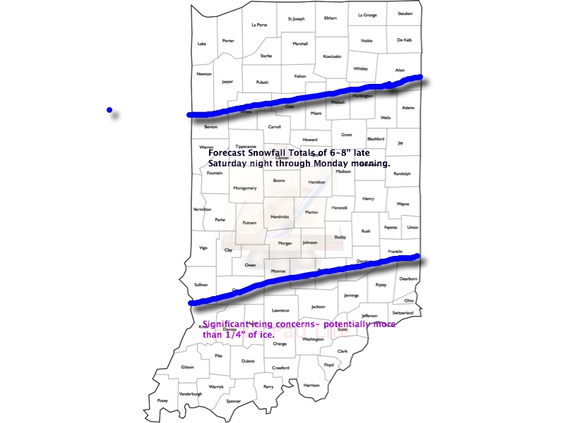
This is an ominous set up for more heavy snow across central Indiana- one that’s notorious for heavy snow events across central Indiana.  We hoisted our initial snowfall forecast Thursday morning and placed central Indiana under the threat for 6-8″.  As of this morning, we’re remaining firm on that idea.  It should be noted that the GFS remains very bullish on heavier totals (and consistent, as well), but it should also be pointed out it’s somewhat of an outlier as of this morning as the GEM and ECMWF are more suppressed with lighter totals.  All of that said, we lean more towards the GFS solution versus the more suppressed Canadian and, to some extent, European forecast model.  Should the other model data begin to trend towards the snowfall idea per the GFS then the initial 6-8″ forecast will have to be adjusted upward.  The storm is just now coming onshore and will be sampled better with model runs later today.

Any way you slice it, a significant and disruptive winter storm is brewing this weekend and could make an absolute mess of your Sunday and Monday.  A shot of bitterly cold air will flow in behind our departing storm early next week.

Our current accumulation idea and storm track can be found below:  We’ll have another update here late tonight and you can keep up-to-date with all of our thoughts on the go on Twitter (@indywx).

WinterStormTrack030214


WinterStorm030214Totals1

Permanent link to this article: https://indywx.com/2014/02/28/more-on-this-weekends-winter-storm/

Winter Storm Watch Hoisted

URGENT - WINTER WEATHER MESSAGE NATIONAL WEATHER SERVICE INDIANAPOLIS IN 405 AM EST FRI FEB 28 2014 ...WINTER STORM TO AFFECT CENTRAL INDIANA... .A WINTER STORM IS PROGGED TO MOVE…

You must be logged in to view this content. Click Here to become a member of IndyWX.com for full access.  Already a member of IndyWx.com All-Access?  Log-in here.

Permanent link to this article: https://indywx.com/2014/02/28/winter-storm-watch-hoisted/

IndyWx.com