January 2014 archive

Historic Snow Season Keeps Rolling Along…

The winter of 2013-2014 is off to a rip-roaring start and, as we’ve discussed in previous posts, the mid to long range data suggests we remain locked in an exceptionally cold and snowy pattern.  Officially, as of this evening, the Indianapolis National Weather Service has posted some impressive stats (the full report can be found here), including:

  • Through Jan. 21st, the 24.4″ of snow ranks as the 3rd snowiest January on record.
  • Through Jan. 21st, the season-to-date snowfall of 33.2″ ranks as the 2nd highest on record in the period Dec. 1st through Jan. 21st.
  • Through Jan. 21st, the season-to-date snowfall of 33.2″ ranks as the 8th snowiest on record for an entire winter season.

As we look ahead to the upcoming 7-10 day period, we note a continuation of arctic reinforcements- each which will be plenty capable of adding to the snowfall total.  Additionally, our cold air mass will only grow even more severe and bitter over time, including multiple days during the aforementioned period where central Indiana will go below zero.  Finally, there have been many questions concerning a potential big storm centered on early February.  I’m not sure where this rumor started, but it’s far too early to say with any sort of confidence any specifics around a possible big winter storm early February.  That said, as we’ll get into briefly below, the pattern does appear to be aligning itself in a way where a widespread winter storm is possible somewhere across the eastern half of the country.

Okay, okay, back to the near term…  Let’s start with tomorrow!  After a cold and dry start to the day, our next arctic front will blow into the region during the evening.  Arctic fronts are notorious for having bursts of heavy snow rates in a scattered fashion and this appears to be the case as the next arctic front moves through Wednesday evening.  We bracket the hours of 5p-8p for the possibility of heavy snow bursts racing through central Indiana.  While these won’t last long, they’ll likely be intense- capable of depositing a quick 1″-2″ of new snow on a gusty northwest wind within 30-60 minutes.  White-out conditions and extremely heavy snowfall rates will accompany the heavier bursts of snow.  Latest high-resolution model data shows the heavy snow bursts accompanying the arctic front tomorrow evening:

hires_ref_indy_31

Thursday will be mostly dry and frigid, but all eyes will then begin to turn to our next significant winter event Friday into Saturday.  The pressure gradient between high pressure across the Mississippi River Valley and the next approaching arctic front (and associated low pressure) will really being to kick up the wind across our region Friday.  We’re afraid we deal with another round of severe blowing and drifting snow Friday, especially Friday afternoon and night.  Areas most suspect to drifting and blowing snow will be central Indiana’s open country and may not be too different from the problems our region dealt with Sunday into Monday morning from blowing and drifting.

As we approach Friday night into Saturday, snow will overspread the region and will likely accumulate to the tune of a “few inches” during this time period.  Strong winds will remain, shifting from the west to the northwest and eventually north.  Open country will remain the prime place for continued severe blowing and drifting problems.

gfs_ptype_slp_east_16

Just as soon as Saturday’s snow systems exits stage right, we turn our attention to potentially another significant snow maker for the second half of the weekend.  Latest model data remains consistent on moving another potent clipper system into our region Sunday, including the GFS and Canadian forecast models.  We still have time to fine tune the precise track of the storm, but just north of the low’s track an additional 3-5″ type snow is possible Sunday.  Note the GFS and Euro in relative agreement on the track of the low, with the Canadian currently a touch further north. We’ll fine tune in the days ahead…  Experience with similar patterns from the past suggests central Indiana should brace for more accumulating snow Sunday.

gfs_ptype_slp_east_22cmc_precip_mslp_east_21

As for the brutal cold, we note multiple pushes of fresh arctic air behind each snow maker.  We currently target Thursday morning, Friday morning, Tuesday morning, next Wednesday morning, and next Friday morning as having the most likely shot at dipping below zero. The “coldest of the cold” likely means Tuesday morning takes the crown, with lows potentially dipping into the double-digit below zero range for central Indiana.  The European forecast model (below) even shows sub-zero temperatures making it as far south as the southern Appalachians.

As we look even longer term, there have been many questions centered on the potential of a big winter storm for early February.  Before we go any further, we want to stress it’s far too early to make any claim of certainty to the above.  That said, there are items we can pick up on to a least “raise an eyebrow” that something of significance may be brewing… Do we mean for anyone to take that verbatim and to the bank?  Absolutely not.

The European Weeklies suggest we need to keep an eye on the first week of February.  They show a potential phasing of the jet (where the northern and southern streams of the jet stream phase together- often times resulting in a big storm)… That said, we want to again stress this is far too early to be discussing with any sort of certainty.  Heh, the next week will keep us busy enough!

Keep the shovel handy!  Snow removal companies, thank you for your service and hard work…hopefully you have plenty of coffee on hand!

Permanent link to this article: https://indywx.com/2014/01/21/historic-snow-season-keeps-rolling-along/

Busy, Snowy Forecast Continues

We posted this to our Twitter page last night (@indywx), but wanted to make sure we posted here, as well.  We’ll discuss this in more detail later tonight.  In addition to this morning accumulating snow event, we’re also tracking (3) additional accumulating snows in our near future.  Keep the shovels handy, friends!

Much more later today!  Travel safely if you must be on area roadways today.

Snow

Permanent link to this article: https://indywx.com/2014/01/21/busy-snowy-forecast-continues/

Snowy Pattern Continues; 2-4″ Expected Tonight-Tuesday

Our snowy pattern is rolling along with no signs of stopping anytime in the foreseeable future. We forecast 2-4″ of new snow tonight through Tuesday morning. A combination of an…

You must be logged in to view this content. Click Here to become a member of IndyWX.com for full access.  Already a member of IndyWx.com All-Access?  Log-in here.

Permanent link to this article: https://indywx.com/2014/01/20/snowy-pattern-continues-2-4-expected-tonight-tuesday/

Locked In The Freezer…

We’ve talked a lot about the relentless weather pattern that has kept our immediate region in what seems like a snow globe since mid December.  Of course we’re on pace…

You must be logged in to view this content. Click Here to become a member of IndyWX.com for full access.  Already a member of IndyWx.com All-Access?  Log-in here.

Permanent link to this article: https://indywx.com/2014/01/19/locked-in-the-freezer/

Winter Just Keeps Going And Going And Going…

As I write this, central Indiana is undergoing yet another winter storm that will dump a fresh 3-5″ of snow by midnight Sunday morning.  We’re well on our way to reaching the snowiest January ever at IND and with the pattern ahead through the end of the month, we very well may just do it.  Before we discuss snow, let’s take a look at the coming shots of arctic air.

While no weather event is identical to another, it’ll be rather easy to compare the coming arctic attack to that which we experienced earlier this month.  That said, there are a couple of important things to consider.  This next wave of arctic air will blow into town when “average” temperatures are at their lowest of the calendar year.  Secondly, data continues to suggest this isn’t just one arctic plunge, but more of a longer duration event when compared to the bitter blast earlier this month.  Needless to say, we’ll need to go into our preparation mode for another round of severely bitter air for the upcoming week.

Let’s look at the model data- note the eastern trough re-amplifying through the period, backing up our idea that this is a rather prolonged arctic event ahead.  As of now, we focus on late in the work week/ next weekend when air temperatures plunge to their respected lowest values (below zero), but want to stress the entire period will be downright cold (much colder than normal), and the long duration event will put more strain on pipes, etc. than a quick-hitting, in and out, arctic outbreak…

When we talk about a longer duration arctic outbreak we’re talking about the possibility of below zero temperatures Wednesday night, Thursday night, Friday night followed by another arctic push that sends lows below zero next Sunday and Monday nights. Stay tuned.

The winter of 2013-2014 is off to a record pace as far as snow totals go.  While we’re not staring at any sort of significant winter storm over the upcoming week, a fast northwest flow can present challenges galore, and any clipper stands the chance to be an “overachiever” as they race southeast over the upcoming week. We fall back on the disclaimer we’ve mentioned in previous posts with clipper systems…the track and strength will be tough for forecast models to iron out until 24-48 hours out.  Secondly, with arctic air firmly in place, snow ratios will be more common around the 20:1 level as opposed to the “normal” 10:1 ratio.

Let’s look at the upcoming snow threats over the next several days…

Our first light snow threat blows in tomorrow night into Tuesday.

GFS1


We then target Wednesday night-Thursday.

GFS2


Finally, we’ll keep a close eye on late week/ next weekend for yet another potential snow event.

GFS3

Permanent link to this article: https://indywx.com/2014/01/19/winter-just-keeps-going-and-going-and-going/

Another Brutally Cold Pattern Setting Up…

The coming several days will result in a continuation of adding to an already expanding snow pack across central Indiana. (We think a 3-5″ band of snow falls for some central Indiana communities Saturday evening and we’ll post on this Friday).  That “ups the ante” for a potentially second round of cold air that flirts with records as we begin to wrap up the month of January and head into February.

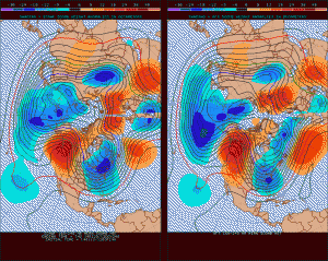
Here’s a look at the latest ensemble package out towards Days 8-10 (Jan 24th-26th time period) and we note a near text book pattern for a severe arctic outbreak across the eastern half of the country.  We want to point out the high latitude blocking combined with a frigid cross-polar fetch.  The GFS and European forecast models (amongst a slew of others) are in excellent agreement on the brutally cold pattern setting up shop, which only adds to our confidence level.

arctic

Okay, okay…the fancy maps above may look confusing to some (and rightfully so), so what does all of this mean to you?  We think we’re looking at multiple nights that feature below zero low temperatures across central Indiana, and potentially in the double digit below zero range yet again.  (Wind chills will be even colder).  We’re looking at the type of cold pattern that could produce multiple days with high temperatures in the single digits to lower teens.

Yes, the winter of 2013-2014 just keeps on keepin’ on and truly shows no signs of letting up.  Hunker down, friends!

Permanent link to this article: https://indywx.com/2014/01/16/another-brutally-cold-pattern-setting-up/

Reviewing The Snowy Details…

After a brief thaw, winter’s set to return with authority in the days and weeks ahead.  In fact, the overall long range weather pattern looks colder and snowier than average into early February, at least.

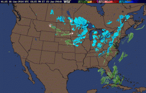
A current look at the National Radar shows the next clipper system taking shape to our northwest this evening.

usa_None_anim

A dive into the latest model data continues to highlight two distinct opportunities for accumulating snowfall in the days ahead.  The first comes Thursday into Friday while the second (potentially more robust) snow maker arrives Saturday afternoon and evening.  By the way, my hat’s off to the GFS for jumping on Saturday’s system well in advance of the other modeling.  Sometimes it’s easy to hammer the GFS, but it should be pointed out during the model’s shining moments, as well.

Back to the near-term… We think widespread snow overspreads central Indiana Thursday morning and continues through the majority of the day and on into Friday in varied intensity.  By the time all is said and done, 2-4″ of new snowfall will be likely across central Indiana, with some locally higher amounts possible.

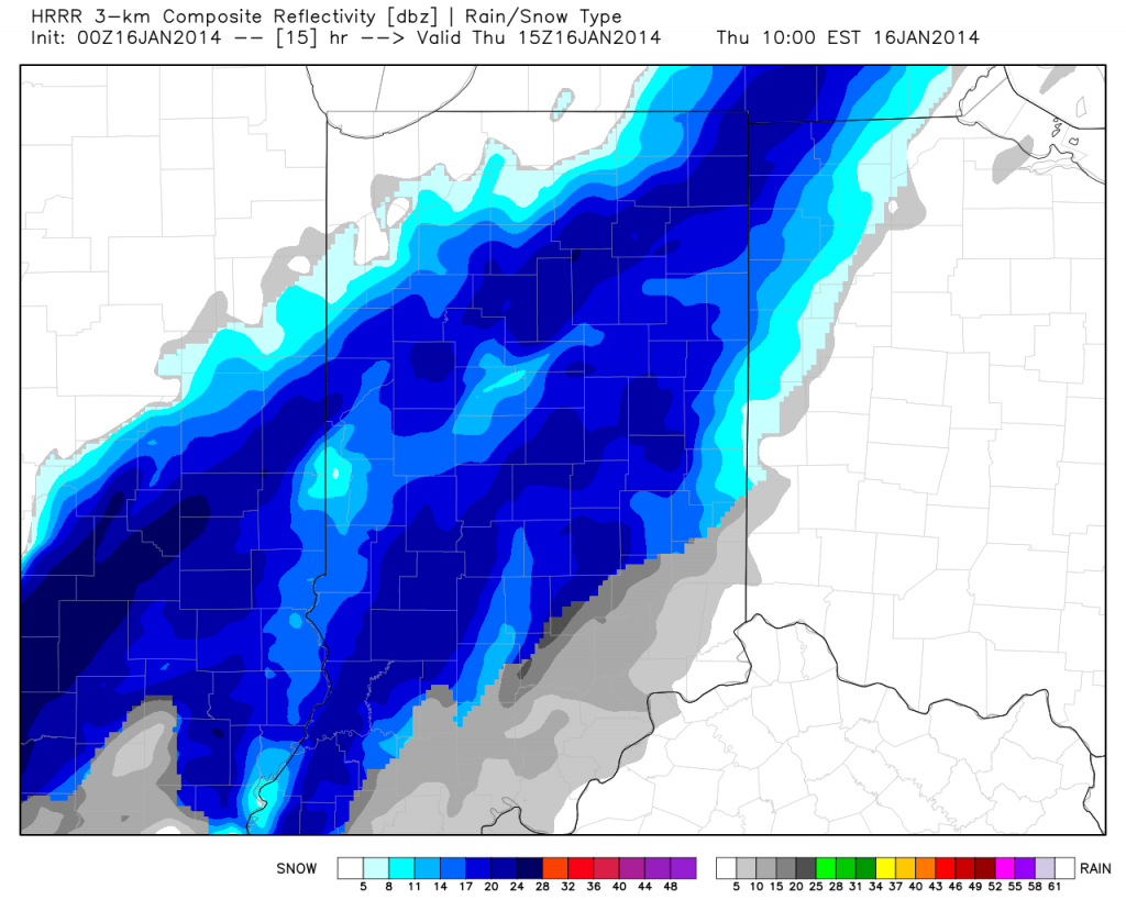
Here’s a look at the latest HRRR simulated radar valid 10am Thursday. Some moderate to briefly heavy snow is possible late morning into the afternoon.

hrrr_ref_indy_16

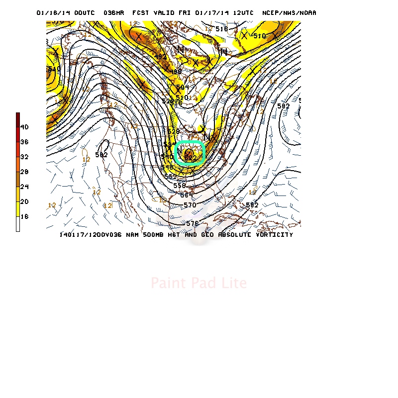
Of interest, we note forecast models carrying a vigorous upper level disturbance across the state Thursday night/early Friday and this will help carry accumulating snow into Friday for some.

500mb

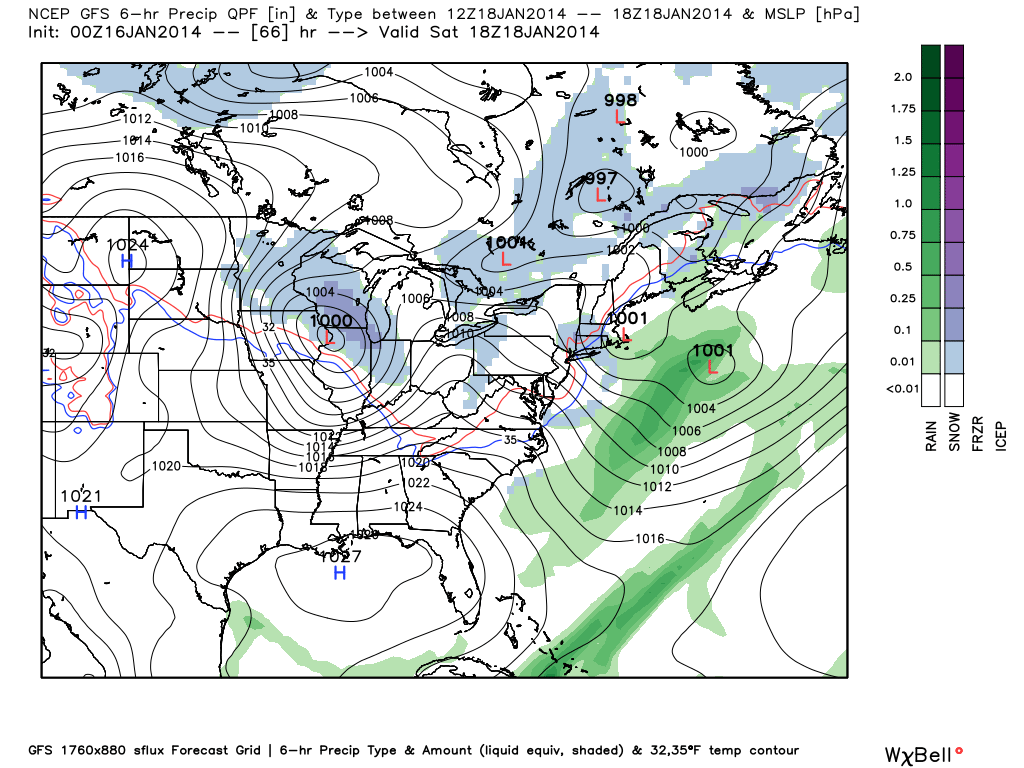
We’ll note an intrusion of briefly drier air Friday afternoon into Saturday morning, but by this time all eyes will be focused on the next clipper system that promises to keep snow shovels and plows busy for parts of Indiana into the weekend.  We think snow overspreads the region from northwest to southeast Saturday afternoon and evening.  Steadiest snow falls Saturday night and could accumulate to the tune of a few inches by daybreak Sunday within the axis of best moisture.  Just to the north of the clipper’s track will be where you find the highest snow totals with Saturday’s system and the precise track of this clipper will be tough to iron out with any sort of certainty until Friday evening.  Stay tuned.  By the way, the snowy and cold events keep on keepin’ on in the longer range…

gfs_ptype_slp_east_12


Permanent link to this article: https://indywx.com/2014/01/15/reviewing-the-snowy-details/

Series Of Fast Moving Snow Makers…

A series of fast moving snow makers will make for busy times in the good ole forecast office in the days (and weeks) ahead.

Of course we’re dealing with scattered snow showers this morning, but this really isn’t a big deal as accumulations will be nothing more than a dusting for most communities.

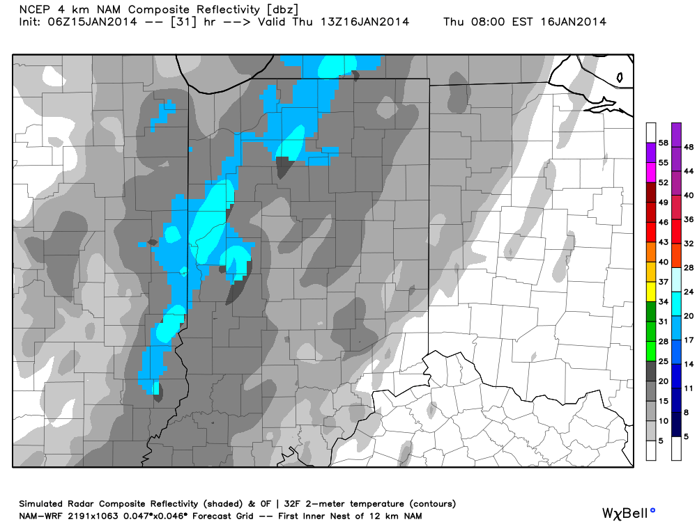
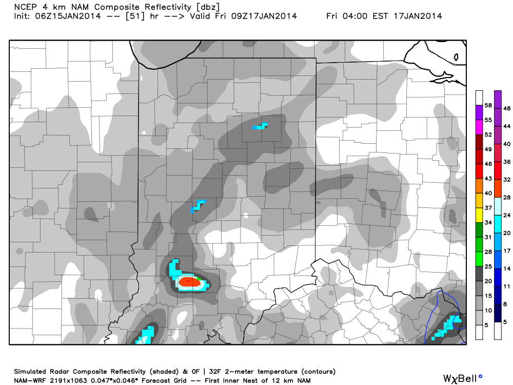
Our next clipper system will deposit light snow and snow showers across the region Thursday and Friday.  Short-term, high resolution data, highlights the chance of some light accumulation Thursday into Friday- generally an inch or less for most.  Here’s a look at the latest simulated radar valid Thursday morning at 8am and Friday at 4am:

hires_ref_indy_32


hires_ref_indy_52

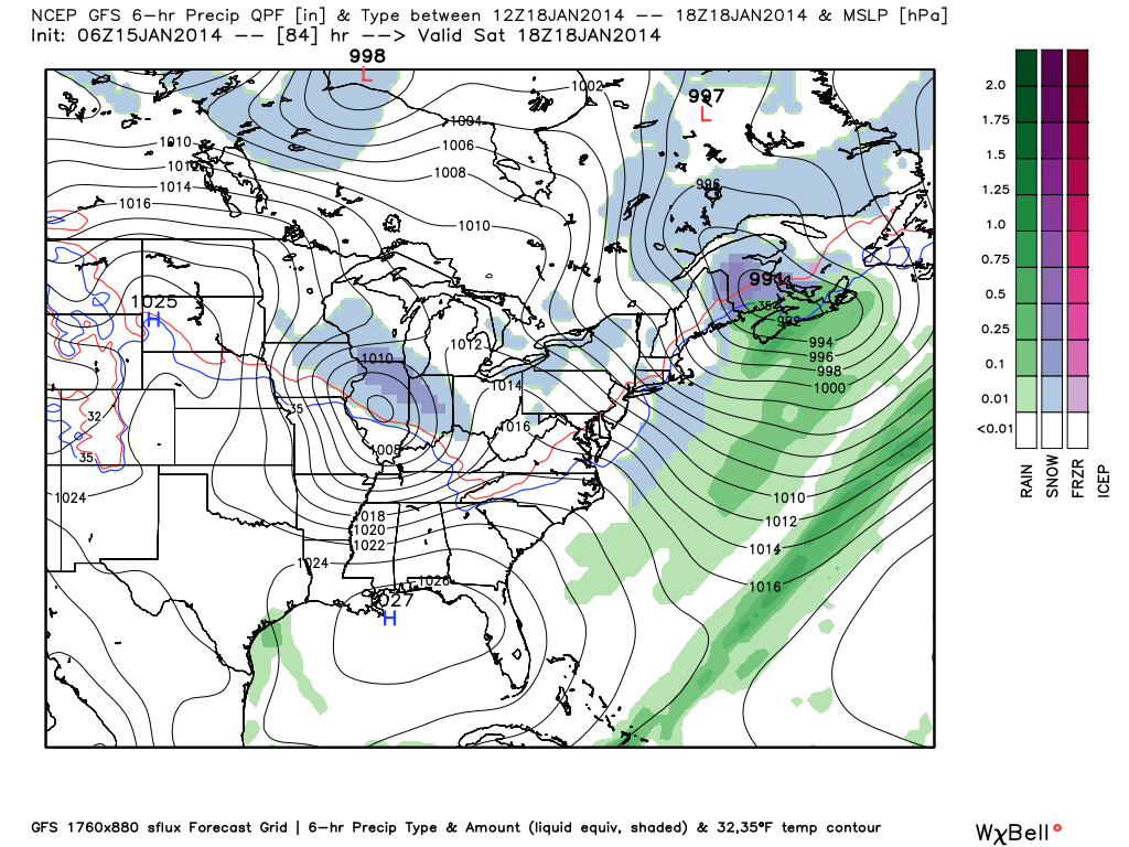
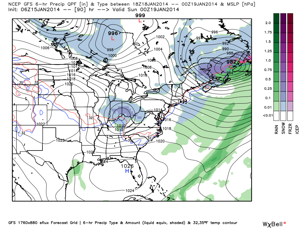
We then look ahead towards Saturday when potentially the best shot of accumulating snow arrives.  The GFS has been leading the way on this system and now other forecast models are following it’s lead.  It’s important to note that these northwest flow systems can be over-achievers (as mentioned in previous posts) and the “fluff effect” can really kick into gear thanks to high snow ratios with the cold air.  We’ll continue to monitor this.  As of now, we think a few inches of snow is possible Saturday as this clipper moves through.  Stay tuned…

gfs_ptype_slp_east_15gfs_ptype_slp_east_16

Permanent link to this article: https://indywx.com/2014/01/15/series-of-fast-moving-snow-makers/

Challenging Northwest Flow…

We’ve made mention of this in the past and we bring this up again as the upcoming weather pattern is one that’s predictable in one sense, but very challenging in another.  We know it’s going to get colder, that we’re confident on.  That said, models will continue to struggle with the details of snow chances, associated with clipper systems diving southeast into the region.  Issues with timing and snowfall amounts are common in these patterns up until 24-48 hours prior to the event.

Case in point, let’s take this weekend. Three forecast models are handling snow chances differently in the Friday-Saturday period.  The European model and Canadian are jumping more on Friday snow (light accumulations), while the GFS is focused on Saturday snow (again, light accumulations)…

Which is the correct solution?  It’s a tough call at this point, but we’ll go with a blend of the three for now, focused on best accumulating snow chances (1-2″ variety) coming late Friday into Saturday morning.  That said, as mentioned above, it’s a tough call and this will require fine tuning as we move forward.  Make it a great day!

The European and Canadian forecast models are honing in on Friday for best chance of light accumulating snow:

cmc_precip_mslp_east_16

Meanwhile, the GFS is focused on Saturday for best snow chances:

gfs_ptype_slp_east_19

Permanent link to this article: https://indywx.com/2014/01/14/challenging-northwest-flow/

Cold, Snowy Pattern Reloading…

I sure hope you’ve taken time to get out and enjoy a couple of days of milder air (temperatures have run 10-12 degrees above seasonal levels the past couple days) and even some sunshine.  Given what I see coming down the road, the trend that looks to take a colder turn this week may really go into the tank week two.

Here’s an overview of the latest GFS and ECMWF ensemble data out at Days 8 through 10 (January 21st-23rd).  Both of these, more trusted, mid to long range computer models suggest a cold pattern locks itself into the East once again, and spells for colder than average temperatures and potentially a snowier than normal regime.

test8


We’ll now dive a little deeper into the forecast model vault, courtesy of the unbelievable Weatherbell Analytics model suite (can’t brag on that company enough).  We’re looking at the Northern Hemisphere Upper Air Pattern, courtesy of the European ensemble control run from this afternoon.

Note the mid week trough set to deliver a return of arctic air into the region.  That’s reinforced with a late week trough and renewed arctic air.  Both cold air masses will be capable of producing light accumulating snow across the area.

Per yesterday’s post, as we get into the early to middle portion of next week, we’ll have to keep a close eye on the potential of the southern and northern branches of the jet stream phasing, which would lead to a significant winter storm across some parts of the eastern half of the country (far too early for specifics or details).

We then note the Polar Vortex recharges itself and threatens to turn the last week to 10 days of January very cold.  How cold is yet to be determined, but I think it’s a safe bet sub-zero temperatures aren’t finished with our area just yet.

Intrusions of very cold arctic air will “pinwheel” around the Polar Vortex and likely lead to a bitterly cold end of January and open to February…

Permanent link to this article: https://indywx.com/2014/01/13/cold-snowy-pattern-reloading/

IndyWx.com