January 2014 archive

Arctic Front Hits Tonight With Wind And Snow Squalls

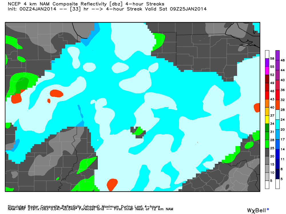
Today will be briefly milder as a nice southwesterly air flow develops and helps send temperatures close to 40 degrees for the city, itself.  Though winds will be gusty, 40 degrees will seem awfully nice!  Enjoy!  It won’t last long though as our next major arctic front already has it’s eyes set on our region.  In fact, we think snow showers and embedded heavier squalls arrive just prior to midnight. These will be short, but intense, bursts of snow and will be capable of producing white out conditions, as well as leading to a quick 1-2″ of fresh snow tonight for many across central Indiana.

Here’s a look at forecast radar tonight, showing the heavy bursts of snow during the overnight.

12

Winds will once again become a problem, gusting in excess of 30 MPH and helping drive in some dangerously cold air.  We think we fall below zero early Monday morning (before the rush hour begins in earnest) and anticipate yet another horrible Monday morning commute.

3

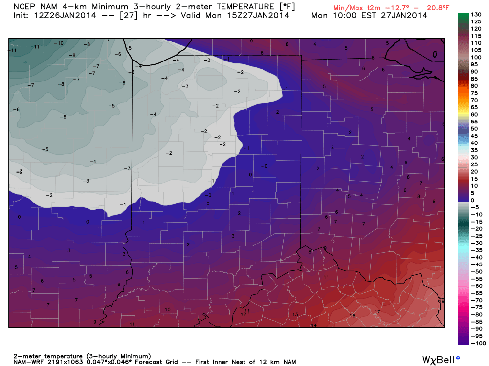
This arctic air really tightens it’s grip heading into Tuesday and we think lows approach 15-20 degrees below zero Tuesday morning.  Below zero readings make it as far south as the southern Appalachians.

We’ll deal with yet another, potentially more widespread, winter event late in the week.  More on that in the coming days…  Enjoy your Sunday!

Permanent link to this article: https://indywx.com/arctic-front-hits-tonight-with-wind-and-snow-squalls/

1st of 3 Rounds Of Wind-Whipped Snow This Weekend!

The first of three rounds of accumulating, wind-whipped, snow is blowing into central Indiana as I type this.  We still think widespread 2-3″ totals fall across many central Indiana neighborhoods during the overnight, with snow ending from north to south between 6-8am.  Additionally, blowing and drifting snow will be a huge concern and local white-outs/ near blizzard conditions will develop into the morning Saturday.  Needless to say, if you don’t have to travel tonight or Saturday, it would be a great time to hunker down at home, start a fire, and enjoy friends and family!

Here’s a look at forecast radar during the “height” of the storm, most likely between 2-4a for most areas:

3

Snow will end Saturday morning, but we’ll have to contend with continued severe blowing and drifting, especially in central Indiana’s open country.  Remain cautious if you must venture out.  Winds will back around from the southwest during the wee morning hours Saturday to a colder (yet again) northwest direction late Saturday morning, resulting in another bitter feel to the air Saturday afternoon.

We’ll enjoy a brief calm period Saturday evening (despite continued gusty winds), but our meteorological eyes will already be poised to the northwest, focused on our next round of accumulating snow Sunday morning. We call this “warm advection” snow as it’ll fall on milder southwest winds ahead of yet another arctic front due in here Sunday night.  This will likely be a  “thumper” snow as additional accumulation Sunday of 1-3″ is a solid bet at this point- most of which falls within a 2-3 hour time period.

2

Sunday afternoon will likely turn drier (and briefly milder) before that “famous” arctic front slams into the region Sunday night. We think additional snow showers and embedded heavier squalls will accompany the frontal passage (FROPA) and could easily lay down yet another half inch to one inch of accumulation Sunday night/ early Monday.

4

All of this additional weekend snow will be capped off with some of the most brutally bitter air so far this season (and that’s obviously saying something, considering how cold it’s been). Gusty northwest winds will lead to continued blowing and drifting issues in the open country early next week, but produce dangerous wind chill values, colder than 30 degrees below zero from time to time.  Additionally, overnight lows Monday night into Tuesday morning will likely fall to between 15 and 20 degrees below zero and highs on Tuesday will likely struggle just to make it to the 0 degree mark for a high…

Permanent link to this article: https://indywx.com/1st-of-3-rounds-of-wind-whipped-snow-this-weekend/

Combo Of Snow & Wind Likely To Cause Problems…

We wanted to take some time to focus solely on our next shot of accumulating snow due in here late Friday night into early Saturday morning.  This will be a quick-hitter, but with snow ratios much higher than normal (thanks to the arctic air mass in place), it won’t take much moisture to fluff up a few inches of powder.

Before we get into the next snow, we can’t ignore what will be a growing concern as morning progresses into afternoon Friday.  The pressure gradient will really begin to tighten between arctic high pressure to our south and the next cold front and associated low pressure to our north.  West winds will increase and gust in excess of 30 MPH by early to mid afternoon.  This will lead to concerns for blowing and drifting in the open country from the existing snow pack in place.  Otherwise, mostly sunny skies will begin to cloud up later in the afternoon and evening.

1

A continued very windy evening will be coupled with light to moderate snow spreading south over the region late Friday night into Saturday morning.  We note the heaviest snow likely to fall in the pre dawn hours Saturday and may become briefly heavy at times.  We forecast 2-3″ of new snow with this system across all of central Indiana, but when you combine a strong west wind, shifting to the northwest Saturday morning, trouble will result.  Significant blowing and drifting snow can be expected through the night and into Saturday.  Travel will likely be very tough late Friday night into Saturday morning.  Not only will we have to contend with severe blowing and drifting, but we’ll also have to deal with local white-out conditions.

The latest high resolution model data shows widespread snow across the region Saturday morning before snow tapers by mid morning from north to south.

hires_ref_streak_indy_34

As mentioned in posts from earlier this week, we’ll also deal with yet another round of accumulating snow for the second half of the weekend and we’ll have more on this tomorrow and Saturday…

Permanent link to this article: https://indywx.com/combo-of-snow-wind-likely-to-cause-problems/

Model Vs. Reality

An intense snow squall blew through central Indiana this evening, thankfully post-rush hour (what a horrendous situation we would’ve had on our hands had this snow burst arrived an hour…

You must be logged in to view this content. Click Here to become a member of IndyWX.com for full access.  Already a member of IndyWx.com All-Access?  Log-in here.

Permanent link to this article: https://indywx.com/model-vs-reality/

Quick Remark On Sunday.

We have enough to worry ourselves with tonight and again Friday night-Saturday, but many are wondering about what Sunday holds.  The consensus of operational model data today is for a north track Sunday, keeping most of the heavy snowfall across northern Indiana.  That said, is it the correct idea?  We’re not ready to buy the extreme north trend just yet…

While anything is possible, the northward trend in operational runs today has me scratching my head a bit given the overall pattern.  Current thinking here would suggest operational models  “correct” south with time over the next couple days, but time will tell.  The GFS ensembles help illustrate the wide variance with the track of Sunday’s snow storm (below).  While the track of the system is still up for debate, confidence is growing on amounts just north of the low’s track that approach half a foot Sunday.  Much more later!

f108

Permanent link to this article: https://indywx.com/quick-remark-on-sunday/