We continue to analyze the latest data concerning our pending severe weather episode ahead Sunday. Today’s information continues to point towards the threat of not only a damaging straight line wind event, but the potential of multiple tornadoes across the central Ohio Valley. The tornado threat would most likely occur with any individual super cells that develop Sunday afternoon. The damaging straight line wind event would then be associated with what’s likely to be a squall line associated with the cold frontal passage Sunday night. Needless to say, Sunday will be busy weather day across not only the Hoosier state, but for many folks across the Mississippi River Valley into the Ohio Valley. Additionally, widespread heavy rain is also a good bet. Let’s look at some data:
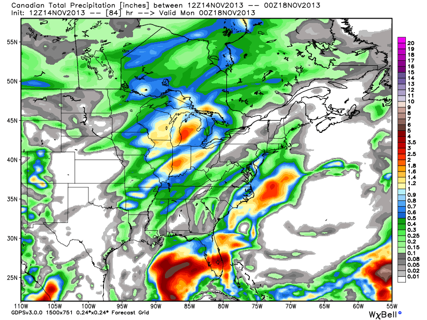
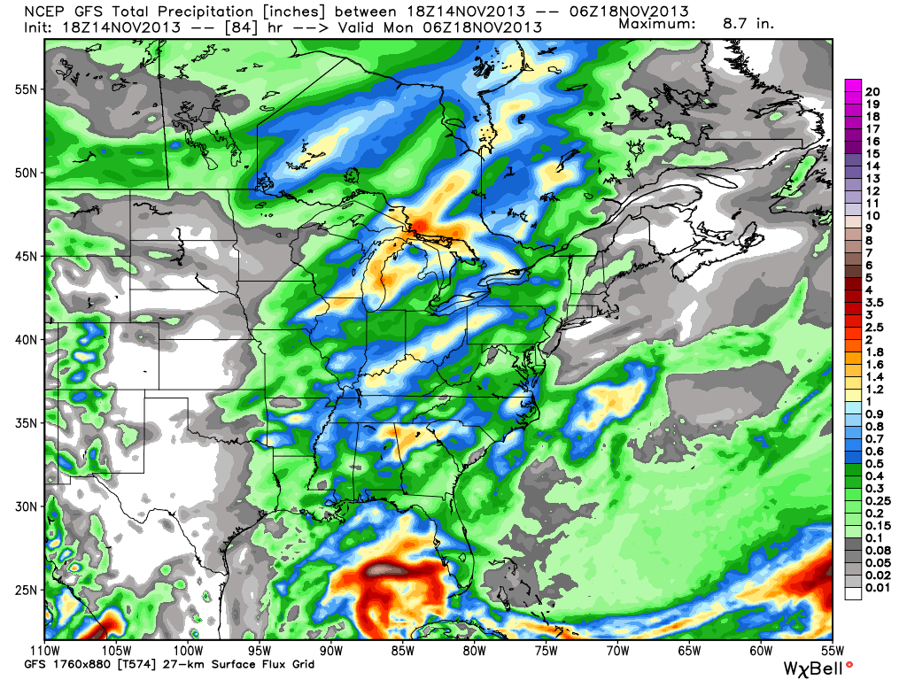
First, let’s look at some rainfall numbers. The ECMWF (European forecast model) and GEM (Canadian forecast model) are the most aggressive with rainfall totals approaching the 2″ mark for many areas of central Indiana between Sunday and Monday. The GFS isn’t as bullish, forecast a little more than half an inch on it’s latest run. Officially we’ll go with a blend of all three models and suggest widespread 1″ type rains across central Indiana during the Sunday-Monday period.

Before we go further, we also want to highlight that winds will be strong and gusty Sunday even well away from any thunderstorms. Winds will likely gust to 40-50 MPH simply by the tightening pressure gradient as surface low pressure begins to “bomb out” (rapidly intensify) on it’s journey into the Great Lakes region.
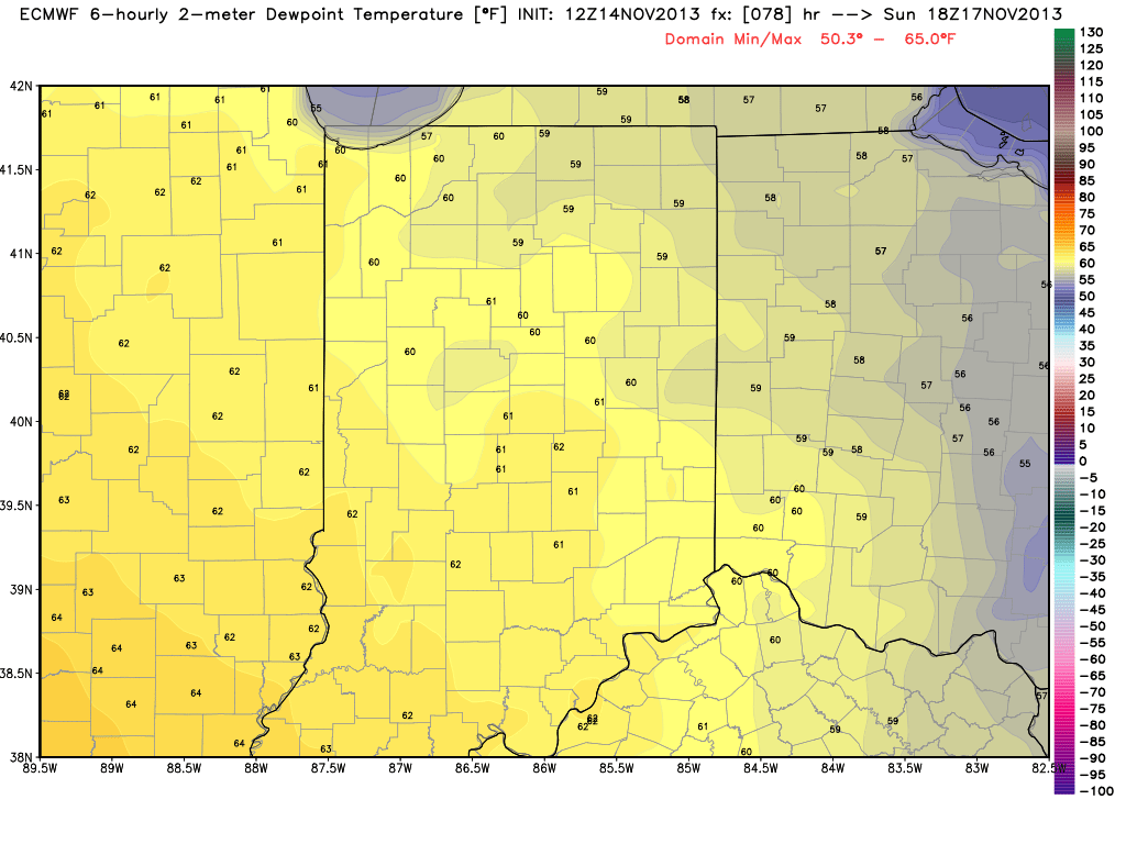
The dynamics are somewhat scary with this event and, as stated above, suggest not only an enhanced straight line damaging wind event, but also the potential of multiple tornadoes associated with any super cells that get going Sunday afternoon, well ahead of the squall line. Despite a cold, dry air mass in place currently, the aforementioned strong southerly winds will help transport dew points into the lower to middle 60s come Sunday afternoon. This will only help add fuel to the fire for storm development.
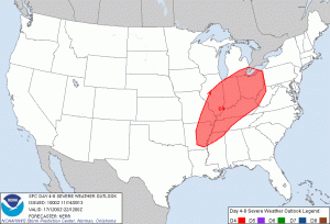
Let’s take a look at the official Severe Weather Outlook for Sunday, courtesy of the Storm Prediction Center. Some highlights from their most recent discussion:
SOME UNCERTAINTY LINGERS...BUT TRENDS IN THE MEDIUM RANGE FORECAST
   GUIDANCE ARE INCREASINGLY SUGGESTIVE OF THE DEVELOPMENT OF AN
   ENVIRONMENT SUPPORTIVE OF AN OUTBREAK OF SEVERE THUNDERSTORMS ACROSS
   PARTS OF THE MIDDLE MISSISSIPPI VALLEY EASTWARD THROUGH MUCH OF THE
   OHIO VALLEY ON SUNDAY.
A 90+ KT 500 MB JET STREAK NOSING THROUGH THE OHIO VALLEY...COUPLED
   WITH STRENGTHENING SOUTHERLY WARM SECTOR 850 MB FLOW...PERHAPS IN
   EXCESS OF 70 KTS ACROSS PARTS OF THE OHIO VALLEY INTO THE LOWER
   GREAT LAKES...WILL CONTRIBUTE TO VERY STRONG DEEP LAYER WIND FIELDS
   AND SHEAR.  IT ALSO APPEARS INCREASINGLY PROBABLE THAT THIS WILL
   COINCIDE WITH AN INFLUX OF SEASONABLY HIGH MOISTURE CONTENT AT LEAST
   AS FAR NORTH AND EAST AS THE LOWER OHIO VALLEY...CONTRIBUTING TO
   SUFFICIENT CAPE FOR VIGOROUS STORM DEVELOPMENT.  SUPERCELLS WITH A
   RISK FOR TORNADOES WILL BE POSSIBLE...PARTICULARLY IN EARLY STAGES
   OF CONVECTIVE DEVELOPMENT...PERHAPS AS EARLY AS MID DAY ACROSS PARTS
   OF THE MIDDLE MISSISSIPPI INTO LOWER OHIO VALLEY VALLEY
EVENTUALLY...THOUGH...ACTIVITY PROBABLY WILL EVOLVE INTO A SQUALL
   LINE WITH DAMAGING STRAIGHT-LINE WINDS BECOMING THE MOST PROMINENT
   SEVERE THREAT.